Banas Kantha
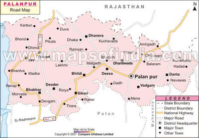
Banas Kantha is a district in Gujarat in India. Its Head Quarter is at Palanpur.
The district is located in the Northeast of Gujarat and is presumably named after the West Banas River which runs through the valley between Mount Abu and Aravalli Range, entering into the plains of Gujarat in this region and flowing towards the Rann of Kutch. The district is famous for the Ambaji temple and the Balaram temple.
Jats in the District
The Jats in district are Muslims known as Verai Jat.
The Gujarati Muslim Jats are a Maldhari cattle hearding group, and are mainly distributed in Kutch and Saurashtra region. They have three territorial divisions, the 1. Halai Jat (found in Jamnagar and Porbandar), 2. Verai Jat (Banaskantha District), and 3. Kutchi Jat (found in Kutch District).
The Kutchi are further subdivided into the Dhanetah, Girasia and Fakirani, the latter consider themselves superior to the other two, and are strictly endogenous. They are further divided into clans like the Badajang, Podani, Aamar, Vangayi, while the Girasia are divided into the Mudrag, Bhallad and Hallayi. All these clans, except the Fakirani, enjoy equal status. The Saurashtra Jat, known as Malaks, maintain a system of Gotra exogamy.[1]
In addition to cattle rearing, the community are also involved in the breeding of camels, especially the Fakirani. A good many of the Saurashtra community are small scale peasant farmers. A few are landless, and work in as agricultural labourers. The Kutch Jat are also known for their embroidery work.
Tahsils in Banas Kantha district
- Amirgadh,
- Bhabhar,
- Danta,
- Dantiwada,
- Deesa,
- Deodar,
- Dhanera,
- Kankrej,
- Palanpur,
- Tharad,
- Vadgam,
- Vav,
History
Notable persons
- Radaji Hakmaji Bhari (PATEL) Ex.Sarpanch Sherpura Mob:09427535352 Tel:02744-255199,255221
- Dr. P H Bhari Mob:09428023280 Tel:02744-221039
- Lakha Ganeshji Bhari (Sub-Inspector in Central Police Organisation)Mob:09427535352
External links
References
- ↑ People of India Gujarat Volume XXI Part Two edited by R.B Lal, P.B.S.V Padmanabham, G Krishnan & M Azeez Mohideen pages 528-533
Back to Gujarat
