Sonipat
| Author:Laxman Burdak, IFS (R) |

Sonipat (सोनीपत) is city and district in Haryana. Its ancient name was Swarnaprastha (स्वर्णप्रस्थ).[1] Other smaller towns are Kharkhoda, Gohana, Ganaur, Murthal and Rai. The total area of Sonipat district is 2,260 sq km and its population is 10,64,000.
Contents
- 1 Variants of name
- 2 Location
- 3 Gotras
- 4 Tahsils in Sonipat district
- 5 Villages in Sonipat tahsil
- 6 Mention by Panini
- 7 History
- 8 In Mahabharata
- 9 सोनीपत के प्राचीन नाम
- 10 सुवर्णप्रस्थ
- 11 सोनपत = सोनीपत
- 12 Geography
- 13 The Khadar
- 14 The Upland Plain
- 15 The Sandy Region
- 16 Notable Jats from Sonipat district
- 17 External Links
- 18 Gallery
- 19 References
Variants of name
- Shonaprastha शोणप्रस्थ दे. Sonipat सोनीपत (AS, p.912)
- Suvarnaprastha सुवर्णप्रस्थ (AS, p.980)
- Sonapata सोनपत = Sonipat सोनीपत, हरयाणा (AS, p.987)
- Sonipat सोनीपत = Sonapata सोनपत (AS, p.989)
- Svarnaprastha स्वर्णप्रस्थ = Suvarnaprastha सुवर्णप्रस्थ (AS, p.1004)
- Shreniprastha (श्रेणीप्रस्थ)
- Swarnaprastha (स्वर्णप्रस्थ)
- Sonaprastha (सोणप्रस्थ)
- Shoṇā-prastha (सोणाप्रस्थ)
- Sunapat (सुणपत)
- Sonepat (सोनीपत)
- Suvarna-prastha (सुवर्णप्रस्थ)
Location
Sonipat is bordered by the states of Delhi and Uttar Pradesh as well as the districts of Rohtak, Jind and Panipat. The River Yamuna runs along the eastern boundary of the district. Sonipat is one of the important districts of Haryana. Sonipat town is the district headquarters. The district touches Delhi on one end, Panipat District on the other, and the Yamuna River acting as a border in one direction and Rohtak on the other side.
Gotras
Tahsils in Sonipat district
District Sonepat comprises of 3 sub-divisions namely Ganaur, Sonepat and Gohana and seven blocks (Ganaur, Sonipat, Rai, Kharkhoda, Gohana, Kathura and Mundlana) has been carved out of Rohtak and made a full fledged district on 22 December 1972. There are four tahsils. Sonepat is the largest tehsil followed by Gohana. Tahsils are:
- Ganaur (गन्नौर)
- Gohana (गोहाना)
- Kharkhoda (खरखौदा)
- Rai (राई)
- Sonipat (सोनीपत)
Bhatgaon, Tihar Kalan, Tihar Khurd, Ratangarh and Garhi Hakikat these 5 villages comes out from Khanda village.
भटगांव, तिहाड़ कलां, तिहाड़ खुर्द, रतनगढ़ और गढ़ी हकीकत इन पांच गांवो की निकासी खांडा गांव से है।
Villages in Sonipat tahsil
(This list consists of villages falling under Sonipat tehsil, and not district Sonipat as a whole).
Abbaspur, Akbarpur Barota, Asadpur, Badh Khalsa, Badshahpur Machhri, Bagru, Bahalgarh, Bakhtawarpur, Baqipur, Barauli, Barwasni, Basaudi, Bayyanpur, Bazidpur Saboli, Bhadana, Bhadi, Bhatana Jafrabad, Bhatgaon Dogran, Bhatgaon Malian, Bidhnauli, Bohla, Chatia Aulia, Chatia Deva, Chhatera Bahadurpur, Chitana Sonipat, Dewarhu, Dhatauri, Dipalpur, Dobheta, Dodwah, Fatehpur, Fajilpur, Guhna, Halalpur, Hansapur, Harsana Kalan, Harsana Khurd, Hasamabad, Hasanyarpur Tihara Kalan, Hassanpur, Hola Heri, Jagdishpur, Jaji, Jajjal, Jakhauli, Jatheri, Jawahri, Joshi Chohan, Joshi Jat, Juan, Kakroi, Kamashpur, Kami, Karar Ibrahimpur, Karewri, Khatkar, Kheri Mana Jat, Khewara, Khizarpur Jat, Khurrampur, Kilorad, Kishora, Kundli, Ladpur, Lawanspur, Levan, Lohari Tiba, Machhraula, Mahipur, Mahlana, Mahra, Majri, Makimpur, Malha Majra, Malkpur, Manoli, Mehndipur, Memarpur, Mirakpur, Mohamdabad, Mohana, Moi, Morthal Khas, Munirpur, Nahra Sonipat, Nahri Sonipat, Naina Tatarpur, Nandnaur, Nangal Kalan, Nangal Khurd, Nasirpur Bangar, Nasirpur Khadar, Nathupur, Nisf Garhi Bakhtawarpur, Palra, Palri Kalan, Palri Khurd, Patla, Pinana, Rahmana, Raipur, Rathdhana, Rewali, Rohat, Rolad Latifpur, Salarpur Majra, Salimpur Torali, Salimsar Majra, Sandal Kalan, Sandal Khurd, Shahjahanpur, Shahpur Turak, Shahzadpur, Shatawli, Sonipat (M Cl), Tajpur, Tihara Khurd, Tharia, Tharu Uldepur, Tikola, Zainpur,
Mention by Panini
Sona-prastha (सोणप्रस्थ) is mentioned by Panini in Ashtadhyayi. [2]
History
V. S. Agrawala[3] writes that Panini mentions village name in category ending Prastha - Shoṇā-prastha, modern Sonepat. To this Kasika adds:Suvarna-prastha. In Pali text Prastha denotes a place outside the grama, a waste land not used by men either for ploughing or sowing. It may be noted that places ending with the Prastha (Hindi=pat) are confined mostly to Kuru Country, such as Panipat, Sonipat, Baghpat, Tilpat etc. and to the region of Himalayas watered by Ganges.
In the South of Sonipat, if we cross Delhi, there is a city called Sona, and in the North of Sonipat, there is a city called Panipat. If we combine these names, it becomes Sonipat. Sonipat was earlier known as Sonprastha, which later on became Swarnprastha, meaning the "Golden City": derived from two Sanskrit words, Swarn (Gold) and Prastha (Place). Over a period of time, the classical name Swarnprasth's pronunciation degraded into Swarnpat, and then to its current form, Sonipat.
The earliest reference of this city comes in the epic Mahabharata, and at that time, it was one of the five villages demanded by the Pandavas in lieu of the kingdom of Hastinapur.
In Mahabharata
It was one of five villages demanded by Pandavas. Mahabharata tells that When Pandavas were defeated in chausar they were forced to leave the state for 13 years. During most of this time, they lived at place called Varnavata (modern Bairat) in Jaipur district in Rajasthan. Having lived there for pretty long time, the Pandawas sent a message to the Kauravas that they won't lay their claim to the throne if they were given just five villages. These 5 villages were :
- Indraprastha (इन्द्रप्रस्थ) (Indarpat) - Purana Kila (Delhi)
- Panaprastha (पणप्रस्थ) (Panipat) - Haryana
- Sonaprastha (सोणप्रस्थ) (Sonipat) - Haryana
- Tilaprastha (तिलप्रस्थ) (Tilpat) - Haryana
- Vyaghraprastha (व्याग्रप्रस्थ) (Bagpat) - Uttar Pradesh
If you study the population of people who lived in all these areas mentioned in Mahabharata it is is found to be the homeland of Jats.
सोनीपत के प्राचीन नाम
इसका शहर का वास्तविक, ऐतिहासिक नाम स्वर्णप्रस्थ है जिसे बाद में सोणप्रस्थ भी कहने लगे । । इस इलाके के गांवों के लोग इसे आज भी सुणपत कहते है, जो कि सोणप्रस्थ का अपभ्रंश रूप है । अंग्रेजों ने इसको अंग्रेजी में Sonepat लिखना शुरू कर दिया जिसके कारण इसको हिन्दी में भी सोनीपत लिखने लग गए ।
सुवर्णप्रस्थ
सुवर्णप्रस्थ (AS, p.980): संभवत: सोनीपत का प्राचीन नाम. [4]
सोनपत = सोनीपत
सोनपत (AS, p.987) = सोनीपत, हरयाणा. प्राचीन नाम संभवत: शोणप्रस्थ या सुवर्णप्रस्थ है. यहां से कन्नौजाधिप हर्षवर्धन (606-647 ई.) की एक ताम्रमुद्रा प्राप्त हुई है जो किसी ताम्र-दानपट्ट से सन्नद रही होगी. दानपट्ट अप्राप्त है. इस मुद्रा पर हर्ष की वंशावली का उल्लेख इस प्रकार है-- महाराज राज्यवर्धन (पत्नी-महादेवी), महाराज आदित्यवर्धन (पत्नी महासेन गुप्ता), परम भट्ठारक महाराजाधिराज प्रभाकर वर्धन (पत्नी-यशोमती), राज्यवर्धन, हर्षवर्धन. प्रभाकर वर्धन को आदित्य अथवा सूर्य का उपासक तथा वर्णाश्रमधर्म का संरक्षक कहा गया है. [5]
Geography
Main water system in the district comprises of River Yamuna and the irrigation canals flowing out of it. There is no perennial river in the district. The underground water resources differ from area to area. The depth of the water table is the lowest in the Khader area along the Yamuna, where it is below 10 ft. It increases to 30 to 40 ft. in some of the western and south eastern part of the district. The ground water in some areas is saline and brackish. The ground water conditions indicate that the district faces the problem of occurrence of brackish water and water logging in eastern parts of the district.
Broadly speaking, the district is a continuous part of the Haryana-Punjab plain, but the area is not leveled in some parts. Over most of the district, the soil is fine loam of rich color. However, some areas has sandy soil and others are comprised of Kallar. The plain has a gradual slope to the south and east. The district may be roughly divided into three regions:
The Khadar
Along the River Yamuna is a narrow flood plain, 3 to 6 km wide, and is formed by the river along its course. The Khader plain is 20 to 30 ft. lower adjoining upland plain. It is comprised of fine clay loam left by the receding floods of the Yamuna. Presently, rice and sugar cane cultivation is undertaken by the farmers in the Khadar area. Recently, the farmers have started planting Banana, Pappaya and other fruits trees in this area.
The Upland Plain
It consists of Sonepat tehsil lying to the west of the Khadar, and is the most extensive of the three regions: The Upland Plain is covered with old alluvium , which if properly irrigated, is highly productive. Extensive Farming of crops, oil seeds, horticultural plants, vegetables and flowers, is undertaken in this region. The ridges in Gohana tehsil represent the northern most extension of the Aravallis.
The Sandy Region
A very smaller part of the district is covered with soil comprising of sand or sandy loam. Parts of this region has high PH value leading to kallor land.
Notable Jats from Sonipat district

- Sanjeev Dahiya (Capt) (10.10.1974-17.07.99) hailed from Sonipat Haryana and was born on 10 Oct 1974 in a military family. He became martyr on 17.07.99 in Akhnoor sector of Jammu and Kashmir during Kargil War.
- Maj Gen Budh Singh Dahiya , bar to military cross
- Major General Balbir Singh Malik from village Bhainswal Kalan.
- Colonel Hoshiar Singh Dahiya from 3 GRDS , the only PVC winner from Haryana
- Hav Rajesh Kumar Dhonchak , Ashok Chakra (P)
- Captain Deepak Sharma, Kirti Chakra (P)
- Lt Cdr Inder Singh Malik, VrC from village Anwali near Bhainswal Kalan.
- Col Mehar Singh Dahiya Shaurya Chakra from Sehri
- Yogeswar Dutt, Olympian
- Deepa Malik, Paralympian
- Jat Mehar Singh Martyr Poet
- Vinod Kumar Dahiya Olympian Wrestler from Khanda
- Amit Kumar Dahiya Olympian Wrestler
- Vijay Dahiya Cricketer
- Rohit Dahiya Cricketer from Khanda
- Amit Dahiya DSP from Khanda
- Manushi Chhillar Miss World
- Gaurav Dahiya Judge from Khanda
- Padam Singh Dahiya Leader from Khanda
- Kundan Singh Freedom Fighter from Khanda
- Ch.Chander Singh (Duhan) HCS : Village Katwal in Sub Division Gohana.
- Rajesh Phogat: HPS 2010, ACP Crime Faridabad, From Sonipat, M: 9729770000
- Rakesh Dahiya: Danics 2011 batch, Posted at Diu ut, CEO, Municipal Council, Diu, From Sonipat, Haryana, M: 9289055456
- Rakesh Dahiya: IRS (Customs and Central Excise) 2010, Posted at Mumbai, from Sonepat, Haryana, M: 9930865570
- Rubal Saroha: IRS (C&CE) 2014 batch, From Sonipat, M: 8587091106
- Sandeep Dahiya: IPS 2014, from Sonipat, Haryana, M: 9416028899
- Saurabh Khatri: Addl Civil Judge(Sn. Div) cum SDJM, Posted at Narwana, Jind, From: Sonipat, M: 8813888512
- Vijay Dhull: IPS 2012 U.P. S.P. Lucknau, From Sonipat, Haryana, M: 9873367383
External Links
Gallery
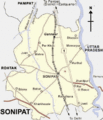
Sonipat Map
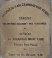
Sir Chhoturam Jamindar High School Sonipat


References
- ↑ Mahipal Arya, Jat Jyoti, August 2013,p. 15
- ↑ V. S. Agrawala: India as Known to Panini, 1953, p. 67
- ↑ V. S. Agrawala: India as Known to Panini, 1953, p.67
- ↑ Aitihasik Sthanavali by Vijayendra Kumar Mathur, p.980
- ↑ Aitihasik Sthanavali by Vijayendra Kumar Mathur, p.987