Almora

Almora (अल्मोड़ा) is a city and district in the state of Uttarakhand, India.
Contents
Variants
Location
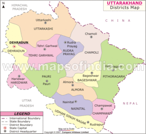
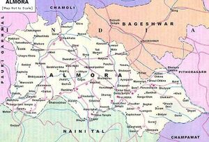
Almora is located on a ridge at the southern edge of the Kumaon Hills of the Himalaya range, at a distance of 363 km (via NH9) from the national capital New Delhi and 415 km via Saharanpur Rd, 351 km via NH109 and 388.6 km via Ambala- Dehradun- Haridwar Rd from the state capital Dehradun.
Etymology
Almora got its name from Bhilmora, a kind of sorrel,(although some have tried to derive it from Berberis "kilmora"[1] a short plant commonly found there [2] which was used for washing the utensils of the sun temple at Katarmal. The people bringing the Bhilmora/kilmora were called Bhilmori/Kilmori and later "Almori" and the place came to be known as "Almora".[3]
When king Bhishm Chand laid the foundation of the town, he had initially named it Alamnagar. Prior to that, Almora was known as 'Rajapur' during the early phase of Chand rule.[4][5] The name 'Rajpur' is also mentioned over a number of ancient copper plates.[6] There is still a place called Rajpur in Almora.
History
Almora was founded in 1568[7] by King Kalyan Chand,[8][9][10] however there are accounts of human settlements in the hills and surrounding region in the Hindu epic Mahabharata[11] (8th and 9th century BCE[12]). Almora was the seat of Chand kings that ruled over the Kumaon Kingdom. It is considered the cultural heart of the Kumaon region of Uttarakhand.
Ancient lore mentioned in Vishnu Purana and Mahabharata present primordial accounts of human settlements in the City.[13]The Sakas, the Nagas, the Kiratas, the Khasas and the Hunas are credited to be the most ancient tribes.[14] The Kauravas and Pandavas of the Hastinapur royal family were the next important princes from the plains who are said to have affected the conquest of these parts.[15]
After the Mahabharata war the district seems to have remained for some time under the sway of the kings of Hastinapur whose authority was never more than nominal.[16]The actual rulers were the local chiefs of whom the Kulindas (or Kunindas) were probably strong in the southern and western part of the city.[17] The Khasas were another ancient people who belonged to an early Aryan stock and were widely scattered in those times.[18] They gave this region the name Khasadesha or Khasamandala.[19][20]
The next age's silent of them may probably be the ones signaling many petty states, rivaling each-other for supremacy and ultimately chartering the inauguration of the noted and enduring dynasty of Chands. Earlier to this, the Katyuris are recorded as the dominant clans in copper and stone engravings.[21] The Chand dynasty from their inception in 953 A.D. to their ouster in the late 18th century present a saga of strife, with horrifying series of wars with rulers of Garhwal culminating in the destruction of this prosperous land and establishment of inglorious Gurkha rule. This dynasty was peculiar in that it made Almora the seat of strongest hill power in 1563 A.D.[22] From that time onwards, the limits of kingdom of Kumaon extended over the entire tracts of districts of Almora and Nainital. Towards the end of the 17th century, Chand Rajas again attacked the Garhwal kingdom, and in 1688, king Udyot Chand erected several temples at Almora, including Tripur Sundari, Udyot Chandeshwer and Parbateshwer, to mark his victory over Garhwal and Doti. The Parbateshwar temple was renamed twice, to become the present Nanda Devi temple.
राजापुर
विजयेन्द्र कुमार माथुर [23] ने लेख किया है ...राजापुर (2) (AS, p.783) = अल्मोड़ा (उत्तराखंड) का प्राचीन नाम.
अल्मोड़ा
विजयेन्द्र कुमार माथुर[24] ने लेख किया है ...अल्मोड़ा (AS, p.44) अल्मोड़ा एक कुमाऊँ की पहाड़ियों में बसा हुआ पहाड़ी नगर है। 1563 ई. तक यह अज्ञात स्थान था। इस वर्ष तक स्थानीय पहाड़ी सरदार चंदराजा बालो कल्याणचंद ने इसे अपनी राजधानी बनाया। उस समय इसे राजापुर कहते थे। ऐतिहासिक आधार पर कहा जा सकता है कि कुमाऊँ का सर्वप्राचीन राजवंश कत्यूरी नामक था। हेनरी इलियट ने कत्यूरी शासकों को खसजातीय सिद्ध करने का प्रयत्न किया है किन्तु स्थानीय परम्परा के अनुसार वे अयोध्या के सूर्यवंशी नरेशों के वंशज थे। 7वीं शती में कुमायूँ में चंदराजाओं का शासन प्रारम्भ हुआ था। 1797 ई. में अल्मोड़ा को गोरखों ने कत्यूरियों से छीन लिया और नेपाल में मिला लिया। 1816 ई. में अंग्रेज़ों और गोरखों की लड़ाई के पश्चात् सुगौली सन्धि के अनुसार अन्य अनेक पहाड़ी स्थानों के साथ ही अल्मोड़े पर भी अंग्रजों का अधिकार हो गया।
अल्मोड़ा परिचय
अल्मोड़ा नगर अल्मोड़ा ज़िले का प्रशासनिक मुख्यालय है और यह उत्तरांचल राज्य, उत्तरी भारत में है। हिमालय की तराई में एक पर्वतश्रेणी पर बसा यह नगर नई दिल्ली से लगभग 275 किलोमिटर पूर्वोत्तर में स्थित है। 1970 में गोरखा लोगों ने अल्मोड़ा पर क़ब्ज़ा कर लिया उन्होंने पर्वतश्रेणी के पूर्वी छोर पर एक दुर्ग का निर्माण किया। एक अन्य दुर्ग पश्चिमी छोर पर स्थित है। 1815 में गोरखों को अल्मोड़ा के पास अंग्रेज़ों के हाथों पराजय का सामना करना पड़ा। यह एक कृषि व्यापार केन्द्र है और यहाँ कुछ निर्माण इकाइयाँ तथा कुमाऊँ विश्वविद्यालय से सम्बद्ध एक महाविद्यालय भी है। सड़क मार्ग के ज़रिये यह नगर दक्षिण स्थित शहरों से जुड़ा हुआ है।
लोककथा: अल्मोड़ा से जुड़ी एक लोककथा भी है जिसके अनुसार- "छह सौ साल पुरानी बात है। उत्तराखण्ड में कुमाऊँ का एक राजा था। वह एक बार शिकार खेलने अल्मोडा की घाटी में गया। वहाँ घना जंगल था। शिकार की टोह लेने के दौरान वहीं झाडियों में से एक खरगोश निकला। राजा ने उसका पीछा किया। अचानक वह खरगोश चीते में बदल गया और फिर दृष्टि से ओझल हो गया। इस घटना से स्तब्ध हुये राजा ने पंडितों की एक सभा बुलाई और उनसे इसका अर्थ पूछा। पंडितों ने कहा इसका अर्थ है कि जहाँ चीता दृष्टि से ओझल हो जाय, वहाँ एक नया नगर बसना चाहिऐ, क्योंकि चीते केवल उसी स्थान से भाग जाते हैं, जहाँ मनुष्यों को एक बडी संख्या में बसना हो। नया शहर बसाने का काम शुरू हुआ और इस प्रकार छह सौ साल पहले अल्मोडा नगर की नींव पडी।
कृषि और व्यापार: यहाँ पर कृषि कार्य मुख्यतः नदी घाटियों तक ही सीमित है। चावल, गेहूँ, फल, मोटे अनाज और चाय यहाँ पर उगाई जाने वाली फ़सलों में शामिल हैं। यहाँ पाए जाने वाले खनिजों में ताँबा और मैग्नेटाइट के भण्डार शामिल हैं।
प्रमुख स्थल: 1. चम्पावत, 2. रानीखेत, 3. दूनागिरि, 4. गणनाथ, 5. द्वाराहाट
पर्यटन: यहाँ के प्रमुख स्थलों में त्रिशूल चोटियाँ, नन्दा देवी का मन्दिर, जहाँ हर साल मेला लगता है। मृग विहार, ब्राइट एण्ड कार्नर, जहाँ लोग सूर्योदय और सूर्यास्त देखने आते हैं और गोविन्द वल्लभ पंत संग्रहालय शामिल हैं, जिसमें इस क्षेत्र की लोक चित्रकला शैली के चित्रों का अच्छा संग्रह है। स्वामी विवेकानन्द ने विश्व भ्रमण के साथ उत्तराखण्ड के अनेक क्षेत्रों में भी भ्रमण किया जिनमें अल्मोड़ा तथा चम्पावत में उनकी विश्राम स्थली को धरोहर के रूप में सुरक्षित किया गया है।
कटारमल सूर्य मंदिर: कटारमल सूर्य मंदिर न सिर्फ समूचे कुमांऊ प्रदेश का सबसे विशाल ऊंचा और अनूठा मंदिर है बल्कि उडीसा के कोर्णाक सूर्य मंदिर के बाद उकमात्र प्राचीन सूर्च मंदिर भी है। रानीखेत अल्मोडा मार्ग पर अल्मोडा से 12 किलोमीटर पहले मुख्य सडक से क़रीब ढाई किमी उपर जाकर कटारमल गांव आता है जिसे बड आदित्य सूर्य मंदिर भी कहा जाता है।
संदर्भ: भारतकोश-अल्मोड़ा
External links
References
- ↑ Kohli, M. S. Mountains of India: Tourism, Adventure and Pilgrimage. Indus Publishing. p. 146. ISBN 9788173871351.
- ↑ "Almora District". www.mapsofindia.com.
- ↑ "Himalayan Region, Almora - BHOR".
- ↑ Riddick, John F. The History of British India: A Chronology. Greenwood Publishing Group. ISBN 9780313322808.
- ↑ Dehradun, NIC, Uttarakhand State Unit. "About us: District of Almora, Uttarakhand, India". almora.nic.in.
- ↑ "Almora History - kmvn Resources and Information". www.kmvn.org.
- ↑ Trivedi, Vijaya R. Autonomy of Uttarakhand. Mohit Publications. p. 33. ISBN 9788174450081.
- ↑ Sharma, Man Mohan. Through the valley of gods: travels in the central Himalayas. Vision Books. p. 99.
- ↑ Bhattacherje, S. B. Encyclopaedia of Indian Events & Dates. Sterling Publishers Pvt. Ltd. p. 55. ISBN 9788120740747.
- ↑ Tyagi, Nutan. Hill Resorts of U.P. Himalaya,: A Geographical Study. Indus Publishing. p. 76. ISBN 9788185182629.
- ↑ Debroy, Bibek. The Mahabharata: Volume 3. Penguin Books India. p. 20. ISBN 9780143100157.
- ↑ Brockington, J. L. (1998). The Sanskrit Epics. BRILL. p. 26. ISBN 9004102604.
- ↑ District Census Handbook (PDF). Dehradun: Directorate of Census Operations, Uttarakhand. p. 8
- ↑ District Census Handbook (PDF). Dehradun: Directorate of Census Operations, Uttarakhand. p. 8
- ↑ Aggarwal, J. C.; Agrawal, S. P. Uttarakhand: Past, Present, and Future. Concept Publishing Company. ISBN 9788170225720., p.166
- ↑ Aggarwal, J. C.; Agrawal, S. P. Uttarakhand: Past, Present, and Future. Concept Publishing Company. ISBN 9788170225720., p.166
- ↑ District Census Handbook (PDF). Dehradun: Directorate of Census Operations, Uttarakhand. p. 8.
- ↑ Aggarwal, J. C.; Agrawal, S. P. Uttarakhand: Past, Present, and Future. Concept Publishing Company. ISBN 9788170225720., p:167
- ↑ District Census Handbook (PDF). Dehradun: Directorate of Census Operations, Uttarakhand. p. 8.
- ↑ Aggarwal, J. C.; Agrawal, S. P. Uttarakhand: Past, Present, and Future. Concept Publishing Company. ISBN 9788170225720., p:167
- ↑ Census of India, 1981: Uttar Pradesh. Series 22. Controller of Publications. p. 1.
- ↑ Saraswati, Baidyanath. The Cultural Dimension of Ecology. Indira Gandhi National Centre for the Arts. ISBN 9788124601020.
- ↑ Aitihasik Sthanavali by Vijayendra Kumar Mathur, p.783
- ↑ Aitihasik Sthanavali by Vijayendra Kumar Mathur, p.44
