Bihar Sharif
| Author:Laxman Burdak, IFS (Retd.) |
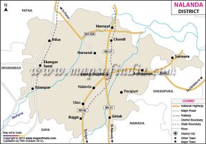
Bihar Sharif is city and headquarters of Nalanda district in Bihar state.
Location
History
The city name is derived from Bihar means Shelter referring to the first halt of 'Ibrahim Malik' (Malik Baya). Sharif means Noble (referring to the descendants of Prophet Mohammed. Syed Ibrahim Mullick settled in Bihar Sharif (India) with his family, and ruled over the region until his assassination on Monday, 13th Zul-Hijjah, 753 Hijri (1353 AD). Syed Ibrahim Mullick`s tomb is over a hill known as Pir Pahari in Bihar Sharif by Muslim residents of city.
Visit by Xuanzang in 637 AD
Alexander Cunningham[1] writes that To the north-east of the isolated mountain of Giryek the Chinese pilgrim Xuanzang travelled from 150 to 160 li, or from 25 to 27 miles, to the Kapotika, or " Pigeon Monastery." Half a mile to the south there was a high solitary hill, on which stood a large vihara of Avalokeswara, surrounded by a multitude of sculptured buildings. This place I would identify with Bihar,
[p.474]:
11 miles to the north-north-east of Giryek, by reading 60 li, or 10 miles, instead of the 160 li of the text.[2] In our maps the name is spelt Behar, but by the people it is written and pronounced Bihar, which is sufficient to show that it must once have been the site of some famous Buddhist Vihar. For this reason I am strongly inclined to identify the great Vihara of Avalokiteswara, which stood on the top of a hill, with the present Bihar, and its great isolated mountain covered with ruins. The hill stands to the north-west of the city of Bihar, with a precipitously steep cliff on its northern face, and an easy slope of successive ledges of rock on the southern face. The summit is now crowned by some Muhammadan buildings; but I discovered amongst the ruins some fragments of Buddhist statues and votive stupas.
To the south-east of the Pigeon Monastery the pilgrim travelled for 40 li, or nearly 7 miles, to another monastery, which stood on an isolated hill. The bearing and distance point to the great ruined mound of Titarawa, which is exactly 7 miles to the south-east of Bihar. Titarawa means " Partridge Mound," that is, the francolin or grey partridge. At Titarawa there is a fine large tank, 1200 feet in length, with a considerable mound of brick ruins to the north, which from its square form has all the appearance of being the re-mains of a monastery.
From this place Hwen Thsang resumed his north- easterly route, and at 70 li, or nearly 12 miles, he reached a large village on the south bank of the
[p.475]: Ganges. But as the nearest point of the river is 25 miles distant, we must read 170 li, or 29 miles, by-adding the round number of 100 li, which was deducted from the previous journey between Giryek and the Pigeon Monastery.
I have considered these two corrections necessary, because Hwen Thsang specially notices the great height of the hill near the Kapotika monastery ; and as I am not aware of the existence of any hills to the north or north-east of Bihar and Titarawa, I am obliged to shorten the one distance and lengthen the other to make Hwen Thsang' s account of his route tally with the actual features of the country. There is a hill at Shekhpura, about 25 miles to the east-north- east of Giryek, 665 feet in height, which might perhaps be the true position of the Pigeon Monastery ; but the adoption of this position would involve an alteration in the subsequent direction of the route, as well as in the distance, as Shekhpura is 20 miles from the Ganges. For these reasons I think that the identification with Bihar is preferable. In either case the village on the Ganges must be looked for near Daryapur, which is 34 miles due west from Mongir in a direct line.
The pilgrim then proceeded to the east for 100 li, or nearly 17 miles, to the monastery and village of Lo-in-ni-lo, which M. Vivien de Saint-Martin has identified with Rohinila[3] or Rohinala, on the Ganges. The actual bearing is nearly south-east ; but as the pilgrim fol- lowed the course of the river, there must be a mistake in his text.
References
- ↑ The Ancient Geography of India/Magadha, p.473-475
- ↑ M. Vivien de Saint-Martia has already noted his suspicion that the 150 to 160 li of the text should be 50 or 60 li. ' Hiouen Thsang," iii. 385, note. See Map No. XII.
- ↑ Julien's ' Hiouen Thsang,' iii. 385.
