Hinganghat
Hinganghat (हिंगणघाट) is a Jat village in Wardha district in the Indian state of Maharashtra. Its ancient name was Danguna (दङ्गुण).
Location
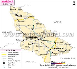
It is about twenty-one miles southeast of the city of Wardha. The town is located on the banks of Vena River, a tributary of Wardha River which joins to Pranhita River, which ultimately flows into the Godavari River.
Hinganghat has been, in the past, a center of the Indian cotton trade, as it is located in the fertile Wardha Valley. Hinganghat is located at 20.57° N 78.83° E. It has an average elevation of 215 metres (705 feet).[1]
In British India Hinganghat was in center of India, but after partition of India & Pakistan the Nagpur is called as center of India.
Demographics
As of 2001 India census, Hinganghat had a population of 92,325. Males constitute 52% of the population and females 48%. Hinganghat has an average literacy rate of 80%, higher than the national average of 59.5%: male literacy is 84%, and female literacy is 75%. In Hinganghat, 11% of the population is under 6 years of age.
History
Poona Plates of 13th year of Prabhavatigupta were issued from Nandivardhana by Prabhavatigupta, the chief queen of the Vâkataka Maharaja Rudrasëna II and mother of the Yuvaràja Divakarasena. She was then acting as Régent for her minor son. The plates record the grant of the village Danguna (दङ्गुण), which is modern Hinganghat.
Notable persons
- Baba Amte India's Social and moral leader, was born December 24, 1914 at Hinganghat.
- William Lambton a British soldier, surveyor, and geographer died at Hinganghat on January 19, 1823 when he was piloting Survey of India, resulting the measurement of Mount Everest
External links
References
Back to Jat Villages
