Dhauli
| Author: Laxman Burdak IFS (R) |

Dhauli (धोली) hills are located on the banks of the river Daya, 8 km south of Bhubaneswar in Orissa, India.
Contents
- 1 Variants
- 2 Location
- 3 Jat clans
- 4 Dhauligiri Shanti Stupa
- 5 History
- 6 Taka kingdom
- 7 Daya River
- 8 भौमकर वंश का कलिंग पर शासन
- 9 धौली
- 10 धौली परिचय
- 11 अश्वत्थामा पर्वत
- 12 धवलगिरि
- 13 उदयगिरि और खण्डगिरि गुफ़ाएँ
- 14 अमित तोसल
- 15 तोसल = तोसलि = धौला (उड़ीसा)
- 16 External links
- 17 Further reading
- 18 Gallery
- 19 References
Variants
- Amit Tosala
- Dhaula (धौला) (उड़ीसा) (AS, p.412)
- Dhauli Hill
- Surabha Hill
- Tosala (AS, p.412)
- Tosali (AS, p.412)
- Toshali
- Amit Tosala (अमित तोसल) (AS, p.33)
- Tosala (तोसल) (AS, p.33)
- Toshala (तोशल) (AS, p.33)
- Tosala तोसल = Tosali तोसलि = Dhaula धौला (उड़ीसा) (AS, p.412)
- Dhaulagiri धौलागिरि = Dhavalagiri धवलगिरि (1) (AS, p.469)
Location
Jat clans
Dhaulya clan of Jats probably get name from Dhauli.[1]
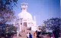
Dhauligiri Shanti Stupa
Dhauligiri Shanti Stupa near Bhubaneswar is well connected by rail, road and air After traveling a distance of 7 KMs from Bhubaneswar towards Puri ( or Konarak ) one can see Dhauligiri Shanti Stupa at the right side ( on Dhauli hills ) just after crossing Daya river bridge. From this point on Puri road (also known as Jaganath road ) the Shanti Stupa distance is 3 Km. This Dhauli Shanti Stupa is also known a Peace Pagoda. Nearest Railway Station is Bhubaneswar and distance from Railway station to Dhauli is 10 Kms. Lord Buddha Status at Dhauligiri Shanti Stupa.
Construction of Stupa: Pandit Jawaharlala Neheru laid the foundation stone of first Shanti Stupa in Bihar state at Rajgiri . After this the then Governor of Bihar Sri Nitya Nanda Kanungo decided to establish second Shanti Stupa at Dhauligiri in Orissa State. He formed Kalinga Nippon Buddha Sangh and became the chairman. Fujii Gurujii along with his young disciples helped in building the Stupa. Nipponzan Myohoji happily beard the entire cost considering it as a offering to Lord Buddha. This Stupa was ready in two year time and got inaugurated on 8th Nov 1972.
History
Ashoka had a special weakness for Dhauli, where the battle was fought. He saw it that Dhauli became an important centre of Buddhist activities. He built several chaityas, stupas and pillars there. He got abodes excavated for the recluse, instructions inscribed for officials, expounded the main principles of 'dandaniti' for the public, provided special status to his new kingdom including the stupas at Dhauli.
Dhauli was witness to some of the goriest battles fought in Orissa. The Kalinga War in 261 B.C. proved to be a turning point in not just Indian history, but also in the way people lived and believed in regions beyond the borders.
The gruesome sight had a morose and repentant Emperor Ashoka take to the teachings of peace and non-violence preached by Lord Buddha. The edicts at Dhauli are a living testimony to King Ashoka's adoption of the doctrine of Dharma Vijay, or conquest through love, over Dig Vijaya, or conquest by the sword.
The Dhauli edicts are written in the Prakrit language using the Brahmi script. It is here that Emperor Ashoka declared his doctrine of paternalism, accepting all men as his children, urging his administrators at Toshali to work for the welfare of Kalinga.
Buddhism in Orissa Excavations at Dhauli have revealed a treasure trove of artifacts which suggest a sophisticated urban settlement dating back to the 3rd century B.C. The Dhauli Hill, also known as the Surabha Hill, is a series of small hills enclosing many rock-cut monuments.
The southernmost range or the Asvathama enfolds rock edicts and a carved elephant within a space of 15 x 10 feet. There is some evidence to suggest a stupa as well on the flat terrace of the hill near the elephant. The Dhavaleswar temple is one of the larger temples in Dhauli, and attributed to the same period as the Lingaraja Temple in Bhubaneswar. The Bahirangeswar Siva temple and the Ganesh shrine are other temples that came up subsequently on the western side.
Tej Ram Sharma[2] writes that N.L. Dey identifies Dakshina Kosala with Tosali of Asoka's inscription (Tosala) at Dhauli, which is situated near Bhuvaneshwar in the Puri district, Orissa. Sylvain Levi suggests an Austric origin for this wold. 'Kosala changing to Tosala is an apparent variation of the initial due to the formative prefix' in the Austric languages. The country of Tosala also, like Kosal, had two divisions : Uttara Tosala and Dakshina Tosala. Daksina Tosala consisted of a mandala of the name of Kongoda. In some cases by mistake the reading Daksina kosala is given in place of Daksina Tosala. But it is clear from other evidence that Tosala and Kosala were two separate entities. The puranas mention them separately. The Kavyamimamsa also makes a separate reference to the two.
Taka kingdom
A Tak kingdom is mentioned by Hiuen-Tsang (631-643 A.D.) It is mentioned as situated towards east of Gandhara. Hiuen-Tasng Gives its name as Tekka, and the History of Sindh, ChachNama, mentions it as Tak. Its capital was Shekilo (Sakala, modern Sialkot) and formerly King Mihiragula was ruling from this place. In seventh century A.D. Its people were not preeminently Buddhists, but worshiped the sun, too. Abhidhana Chintamani Says that Takka is the name of Vahika country (Punjab). For what follows, we are indebted to Chandrashekhar Gupta for his article on Indian coins. [3] The Tanks must have come to India, Prior to fourth century A.D. i.e. with the Kushana. And with the Kushanas, they must have spread up to Bengal and Orissa, like the Manns and Kangs who spread into southern Maharashtra and the Deccan. In Orissa, the Tanks, had their rule in Orissa proper, Mayurbhanj, Singbhoom, Ganjam, and Balasore Districts. They are called by historians as “ Puri Kushans” or Kushanas of Puri (Orissa). Their coins have been found at Bhanjakia and Balasore (Chhota Nagpur) and these coins have the legend Tanka written in Brahmi script of the fourth century A.D. Allan suggested the reading Tanka as the name of a tribe “ [4] and others generally accepted the reading Tanka as correct. [5] Allan placed them in the third or early fourth century A.D., while V.A. Smith placed them in the fourth or fifth century A.D. ; R.D. Bannerji called them “ Puri Kushanas” [6]
According to Dr Naval Viyogi, It seems from the aforesaid evidence of coins that some branch Tanka of Taka royal family owing to attack of Kushanas up to Magadha, reached Mayurbhanj, Singhbhumi, Ganjam and Balasore and established colonies there, where remains of their offshoot, the royal family of Dhavaldev is still existing at Dalbhumigarh near Kharagpur. [7]
The Dhauli hills located on the banks of the river Daya, 8 km south of Bhubaneswar in Orissa (India also supports this view. It gets name from Dhaulya clan of Jats.
The Rock Edicts found here include Nos. I-X, XIV and two separate Kalinga Edicts. In Kalinga Edict VI, he expresses his concern for the "welfare of the whole world". The rock-cut elephant above the Edicts is the earliest Buddhist sculpture of Orissa. The stone elephant shows the animal foreparts only, though it has fine sense of form and movement. It has another significance, which is related to earth in form of an elephant, and to that extent, elephant probably represented the Buddha to devotees.
Daya River
Daya River, a tributary of Mahanadi, flows through the districts of Khordha and Puri in Orissa in India. The historically important Dhauli hills are located on the banks of the river Daya, 8 km south of Bhubaneswar in Orissa (India. It is a hill with vast open space adjoining it, and has major Edicts of Ashoka engraved on a mass of rock, by the side of the road leading to the summit of the hill. Dhauli hill is presumed to be the area where Kalinga War was fought.
भौमकर वंश का कलिंग पर शासन
कलिंग (उड़ीसा) पर माठर वंश के बाद 500 ई० में नल वंश का शासन आरम्भ हो गया। नल वंश के बाद विग्रह एवं मुदगल वंश, शैलोद्भव वंश और भौमकर वंश ने कलिंग पर राज्य किया। पूर्व में भौमकर शासकों ने उत्तर तोसली पर शासन किया और वे शैलोद्भव शासकों के समकालीन थे जो उत्तरी कोंगोद के शासक थे । राजा शिवकर प्रथम (756 या 786 ई.) के समय तक उड़ीसा के अधिकांश तटीय प्रदेशों पर उनका कब्जा हो गया था। श्वेताक गंग राजा जयवर्मदेव के गंजम शिलालेख के अनुसार शिवाकर प्रथम ने कोंगोद और कलिंग के उत्तरी भागों पर विजय प्राप्त की।
भौमकर वंश के सम्राट शिवाकरदेव द्वितीय की रानी मोहिनी देवी ने भुवनेश्वर में मोहिनी मन्दिर का निर्माण करवाया। वहीं शिवाकर देव द्वितीय के भाई शान्तिकर प्रथम के शासन काल में उदयगिरी-खण्डगिरी पहाड़ियों पर स्थित गणेश गुफा (उदयगिरि) को पुनः निर्मित कराया गया तथा साथ ही धौलिगिरि पहाड़ियों पर अर्द्यकवर्ती मठ (बौद्ध मठ) को निर्मित करवाया। यही नहीं, राजा शान्तिकर प्रथम की रानी हीरा महादेवी द्वारा 8वीं ई० हीरापुर नामक स्थान पर चौसठ योगनियों का मन्दिर निर्मित करवाया गया।
उसके वंशज शिवकर तृतीय के तलचर शिलालेख से पता लगता है कि उसने राढ़ शासक को पराजित किया और पराजित राजा की पुत्री से शादी की थी।
धौली
विजयेन्द्र कुमार माथुर[8] ने लेख किया है ... 1.धौली = दे. धवलगिरी (2). पहाड़ी की एक चट्टान पर अशोक की 14 मुख्य धर्मलिपियों में से 1-10, 14 और दो कलिंग-लेख अंकित हैं. कलिंग लेख में कलिंग युद्ध तथा तत्पश्चात अशोक के हृदय परिवर्तन का मार्मिक वर्णन है. कलिंग युद्ध की स्थली धौली की चट्टान के पास ही स्थित रही होगी. अभिलेख में इस स्थान का नाम तोसलि है. यह स्थान भुवनेश्वर के निकट और प्राचीन शिशुपाल गढ़ के खंडहरों से 2 मील दूर दया नदी के तट पर स्थित है. (देखें तोसल या तोसलि) दया नदी का नाम संभवत: अशोक के हृदय में कलिंग युद्ध के पश्चात दया का संचार होने के कारण ही पड़ा था. धौली की पहाड़ी को अश्वत्थामा पर्वत भी कहते हैं.
2. धौली = धौलीगंगा: जिला गढ़वाल (उत्तर प्रदेश): गढ़वाल की एक नदी जो नीतिघाटी में बहती हुई विष्णुप्रयाग में आकर अलकनंदा (गंगा) में मिलती है.
धौली परिचय
धौली उड़ीसा के भुवनेश्वर से 8 किमी की दूरी पर स्थित एक ऐतिहासिक स्थान है। इस स्थान से अशोक के चतुर्दश शिलालेखों की एक प्रति प्राप्त हुई है। जौगढ़ की भाँति यहाँ भी संख्या 11, 12 तथा 13 के लेख नहीं मिलते, उनके स्थान पर दो अन्य लेख मिले है, जो विशेषरूप से कलिंग के लिए उत्कीर्ण कराये गये थे। धौली वही जगह है, जहाँ कलिंग युद्ध के पश्चात् सम्राट अशोक ने स्वयं को पश्चाताप की अग्नि में जलता हुआ महसूस किया था। इस पश्चाताप के फलस्वरूप अशोक ने पूर्ण रूप से बौद्ध धर्म को स्वीकार कर लिया। बौद्ध धर्म स्वीकार करने के बाद अशोक ने जीवन भर अहिंसा का सन्देश दिया तथा बौद्ध धर्म का प्रचार-प्रसार किया। अशोक के विश्व प्रसिद्ध पत्थर के स्तम्भों में से एक यहीं पर है। इस स्तम्भ में सम्राट अशोक के जीवन से जुड़े तथ्यों का वर्णन किया गया है। धौली का शांति स्तूप भी काफ़ी प्रसिद्ध है, जो धौली पहाड़ी के ऊँचे स्थान पर बना है। शांति स्तूप में महात्मा बुद्ध के जीवन को दर्शाती हुई कई मूर्तियाँ हैं। शांति स्तूप के पास से ही दया नदी का बड़ा ही प्यारा दृश्य दिखाई देता है।
संदर्भ: भारतकोश-धौली
अश्वत्थामा पर्वत
विजयेन्द्र कुमार माथुर[9] ने लेख किया है ...अश्वत्थामा पर्वत (AS, p.51) भुवनेश्वर से 2 मील पर स्थित है। इसे 'धवलागिरि की पहाड़ी' नाम से भी जाना जाता है। अश्वत्थामा पर्वत में मौर्य सम्राट अशोक का एक अभिलेख उत्कीर्ण है। कहते हैं कि इतिहास-प्रसिद्ध कलिंग युद्ध जिसने अशोक के हृदय को बदल दिया था, इसी स्थान पर हुआ था। पर्वत पर पहले अश्वत्थामा विहार स्थित था।
धवलगिरि
विजयेन्द्र कुमार माथुर[10] ने लेख किया है ...1. धवलगिरि (AS, p.465) = धौलागिरि (दे. श्वेतपर्वत)
2. धवलगिरि धवलगिरि अथवा 'धवलागिरि' भुवनेश्वर, उड़ीसा से 2 मील (लगभग 3.2 कि.मी.) की दूरी पर स्थित एक पहाड़ी का नाम है। इस पहाड़ी को 'अश्वत्थामा पर्वत' के नाम से भी जाना जाता है। इस पहाड़ी में मौर्य सम्राट अशोक का प्रसिद्ध 'कलिंग अभिलेख' उत्कीर्ण है, जिसमें कलिंग के युद्ध तथा तज्जनित अशोक के हृदय परिवर्तन का मार्मिक वृत्तान्त है। संभवत: कलिंग युद्ध की स्थली धवलगिरि की पहाड़ी के निकट ही थी। धवलगिरि पहाड़ी को 'अश्वत्थामा पर्वत' भी कहते हैं।
उदयगिरि और खण्डगिरि गुफ़ाएँ
2. उदयगिरि और खण्डगिरि गुफ़ाएँ ( p.95): भुवनेश्वर (उड़ीसा) के समीप नीलगिरि, उदयगिरि तथा खण्डगिरि नामक गुहा समूह में 66 गुफाएँ हैं जो पहाड़ियों पर अवस्थित हैं. इनमें से अधिकांश का समय तीसरी शती ई.पू है. और उनका संबंध जैन संप्रदाय से है.
उदयगिरि और खण्डगिरि नामक दो गुफ़ाएँ जो भुवनेश्वर (उड़ीसा) के समीप दो पहाड़ियाँ पर स्थित है। ये गुफ़ाएँ उदयगिरि और खण्डगिरि पहाडियों में पत्थरों को काट कर बनाई गई थी। यहाँ से कलिंग के प्रसिद्ध शासक खारवेल का अभिलेख है। इसका विस्तृत अध्ययन श्री काशी प्रसाद जायसवाल बहुत समय तक करते रहे थे. अभिलेख में पहाड़ी को कुमारगिरि कहा है. यह स्थान उड़ीसा की प्राचीन राजधानी शिशुपालगढ़ से 6 मील दूर है. इसी स्थान के पास अशोक के समय में तोसलि नाम की नगरी (वर्तमान धौली) बसी हुई थी. वास्तव में उड़ीसा के इसी भाग में इस प्रदेश की मुख्य राजधानियाँ बसाई गई थी.
अमित तोसल
विजयेन्द्र कुमार माथुर[11] ने लेख किया है ...अमित तोसल (AS, p.33) जनपद का उल्लेख गंडव्यूह नामक ग्रन्थ में है। यह संभवत: तोसल या तोसलि का प्रदेश था जो उड़ीसा में भुवनेश्वर के निकट स्थित वर्तमान धौली नामक स्थान है।
तोसल = तोसलि = धौला (उड़ीसा)
विजयेन्द्र कुमार माथुर[12] ने लेख किया है ...तोसल या तोसलि = धौला (उड़ीसा) (AS, p.412): भुवनेश्वर के निकट शिशुपालगढ़ के खंडहरों से तीन मील दूर धौली नामक प्राचीन स्थान है, जहाँ अशोक की कलिंग धर्मलिपि चट्टान पर अंकित है। इस अभिलेख में इस स्थान का नाम 'तोसलि' है और इसे नवविजित कलिंग देश की राजधानी बताया गया है। यहाँ का शासन एक 'कुमारामात्य' के हाथ में था। अशोक ने इस अभिलेख के द्वारा 'तोसलि' और समापा के नगर व्यावहारिकों को [p.413]: कड़ी चेतावनी दी है, क्योंकि उन्होंने इन नगरों के कुछ व्यक्तियों को अकारण ही कारागार में डाल दिया था।
सिलवनलेवी के अनुसार 'गंडव्यूह' नामक ग्रंथ में 'अमित तोसल' नामक जनपद का उल्लेख है, जिसे दक्षिणापथ मे स्थित बताया गया है। साथ ही यह भी कहा गया है कि इस जनपद में तोसल नामक एक नगर है। कुछ मध्यकालीन अभिलेखों में दक्षिण तोसल व उत्तर तोसल का उल्लेख है (एपिग्राफ़िका इंडिया, 9, 586,15, 3) जिससे जान पड़ता है कि तोसल एक जनपद का नाम भी था। प्राचीन साहित्य में तोसलि के दक्षिणकोसल के साथ संबंध का उल्लेख मिलता है। टॉलमी के भूगोल में भी तोसली (Toslei) का नाम है। कुछ विद्वानों (सिलवनलेवी आदि) के मत में कोसल, तोसल, कलिंग आदि नाम ऑस्ट्रिक भाषा के हैं। ऑस्टिक लोग भारत में द्रविड़ों से भी पूर्व आकर बसे थे। धौली या तोसलि 'दया नदी' के तट पर स्थित हैं।
External links
Further reading
- Sachin Singhal: Orissa tourist road guide and political, Vardhman Publications, ISBN 81-8080-011-3
- Bimalendu Mohanty: Orissa yesterday, today and tomorrow, Nur Publishers Bhubaneswar, India, 2003. ISBN 81-883450-00-8
- Dhauli.com: Official Website of Dhauli
Gallery
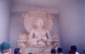
शांति स्तूप धौली में बुद्ध प्रतिमा
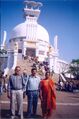
शांति स्तूप धौली में एसपी सिंह, लक्ष्मण बुरड़क & गोमती बुरड़क
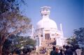
शांति स्तूप धौली
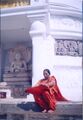
शांति स्तूप धौली में गोमती बुरड़क
शांति स्तूप धौली


References
- ↑ Mahendra Singh Arya et al.: Ādhunik Jat Itihas, Agra 1998, p.258
- ↑ Personal and geographical names in the Gupta inscriptions/Place-Names and their Suffixes,p.258
- ↑ Vishveshvaranand Indological Journal (Hoshiarpur, Pb.) Vol, XVI, pt. I. p.92 ff
- ↑ Ancient India, Plate XII, fig. 3
- ↑ Journal of Numismatic Society of India, 12, 1950 p.72
- ↑ Bhim Singh Dahiya, Jats the Ancient Rulers ( A clan study), p.274
- ↑ Dr Naval Viyogi: Nagas – The Ancient Rulers of India,
- ↑ Aitihasik Sthanavali by Vijayendra Kumar Mathur, p.469
- ↑ Aitihasik Sthanavali by Vijayendra Kumar Mathur, p.51
- ↑ Aitihasik Sthanavali by Vijayendra Kumar Mathur, p.465
- ↑ Aitihasik Sthanavali by Vijayendra Kumar Mathur, p.33
- ↑ Aitihasik Sthanavali by Vijayendra Kumar Mathur, p.412-413
Back to Orissa
Back to Jats in Buddhism