Dibang River
| Author:Laxman Burdak, IFS (R) |
Dibang River (दिबांग नदी) flows through Arunachal Pradesh and Assam states of India. It is an upstream tributary river of the Brahmaputra. It is also known as Sikang by the Adi and Talo in Idu,[1] It originates and flows through the Mishmi Hills from the state of Arunachal Pradesh and Nyingchi Prefecture in the Tibet Autonomous Region.[2]
Variants
Course
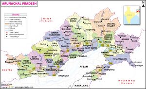
The Dibang originates near Keya pass on the Indo-Chinese border in the Upper Dibang Valley district of Arunachal Pradesh. The drainage basin of the river within Arunachal Pradesh covers the districts of Upper Dibang Valley and Lower Dibang Valley. The Mishmi Hills lie in the upper course of the Dibang which enters the plains at Bomjir, Dambuk etc.
Between Bomjir (Nizamghat) and Sadiya the Dibang has a steep river gradient and exhibits braided channel morphology, with its width varying from 4 to 9 kilometres. It often changes its course, resulting in flooding and destruction of cultivable land and forests along its banks. The Dibang, with a total length of 195 kilometres, enters the Lohit River north of the Dibru-Saikhowa sanctuary near the Assamese town of Sadiya in Tinsukia district, Assam.
Tributaries
The Sisar, Mathun, Tangon, Dri, Ithun and Emra are the major tributaries of the Dibang. The Dibang is also joined by a number of tributaries such as the Airi, Ilu, Imu, Ahi, Ashu, Epipani and Eze (Deopani) rivers during its course. Most of these rivers join it in the upper course in the hills thus giving it a wide fan shaped catchment region.
History
Historically, the region between the Lohit River and the Dibang River was known as Sadhayapura as per copper inscriptions.
दिबांग नदी
दिबांग नदी ब्रह्मपुत्र नदी की एक उपनदी है जो भारत के असम और अरुणाचल प्रदेश राज्यों में बहती है। दिबांग नदी अरुणाचल प्रदेश के ऊपरी दिबांग घाटी ज़िले में भारत-तिब्बत सीमा पर स्थित केया दर्रे के समीप उत्पन्न होती है। अरुणाचल प्रदेश में ऊपरी दिबांग घाटी ज़िले व निचली दिबांग घाटी ज़िले पर इसका जलसम्भर विस्तृत है। अपने ऊपरी भाग में यह मिश्मी पहाड़ियों से होती हुई निज़ामघाट के बाद मैदानी क्षेत्र में प्रवेश करती है। निज़ामघाट और सदिया के बीच यह काफ़ी ऊँचाई से नीचे आती है और कई धाराओं में बंट जाती है। यहाँ इसकी चौड़ाई ४ से ९ किमी के बीच है और लगातार मार्ग परिवर्तन से यहाँ की भूमि पर बाढ़ आती रहती है। 195 किमी के कुल मार्ग को तय करके यह डिब्रू-सैखोवा राष्ट्रीय उद्यान से उत्तर में और सदिया के पास लोहित नदी में विलय हो जाती है।
External links
References
- ↑ Pisharoty, Sangeeta Barooah (22 July 2019). "Explainer | The Controversy Surrounding Dibang Dam, India's Largest Hydropower Project". The Wire.
- ↑ R. S. Envirolink Technologies (July 2016). Cumulative Impact & Carrying Capacity Study of Dibang Sub Basin on Brahmaputra River Valley. Volume I. Prepared for Ministry of Environment, Forest and Climate Change. Accessed on 16 June 2021.
Back to Rivers
