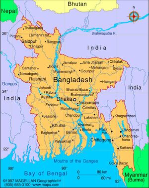
Faridpur Bangladesh
- Note - Please click → Faridpur for details of similarly named villages at other places.
| Author:Laxman Burdak, IFS (R) |

Faridpur (Hindi:फरीदपुर, Bengali: ফরিদপুর জেলা) is a district in south-central Bangladesh. It is a part of the Dhaka Division.[1] The district is named after the municipality of Faridpur. Historically, the town was known as Fatehabad. It was also called Haveli Mahal Fatehabad.
Variants
- Faridpur Bangladesh फरीदपुर, बांग्लादेश, (AS, p.597)
Location
It is bounded by the Padma River to its northeast.
History
Tej Ram Sharma [2] writes ....The regnal period of Vainyagupta witnessed a considerable decline in the power and prestige of the Imperial Guptas. The rise of the ruling dynasty consisting of Dharmaditya, Gopachandra and Samacharadeva in Central and South-West Bengal in the first half of the sixth Century A.D., possibly points to the extirpation of Gupta rule from Bengal excepting the bhukti (province) of Pundravardhana (North Bengal).[3]
फ़रीदपुर
विजयेन्द्र कुमार माथुर[4] ने लेख किया है .....फ़रीदपुर नगर, बंगाल (AS, p.597): गुप्तकाल में फ़रीदपुर नगर के परिवर्ती क्षेत्र का नाम वारक-मंडल था। फ़रीदपुर से गुप्तकालीन नरेश 'धर्मादित्य' तथा 'गोपचन्द्र' के तीन दानपट्ट-अभिलेख प्राप्त हुए हैं जिनसे तत्कालीन भूमि-हस्तांतरण तथा सामान्य शासन-व्यवस्था के बारे में सूचना मिलती है।
External links
References
- ↑ Masud Reza (2012). "Faridpur District". In Sirajul Islam and Ahmed A. Jamal (ed.). Banglapedia: National Encyclopedia of Bangladesh (Second ed.). Asiatic Society of Bangladesh.
- ↑ Personal and geographical names in the Gupta inscriptions/Names of the Gupta Kings and Queens,p.29
- ↑ The Vakatka-Gupta Age by R. C. Majumdar and A.S. Altekar. pp. 210-11
- ↑ Aitihasik Sthanavali by Vijayendra Kumar Mathur, p.597