Gangtok
| Author:Laxman Burdak, IFS (R) |


Gangtok (गंगटोक) is a city and the capital town of the Indian state of Sikkim. It is also the headquarters of the East Sikkim district.
Location
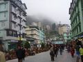
Gangtok is in the eastern Himalayan range, at an elevation of 5,410 ft. Within the higher peaks of the Himalaya and with a year-round mild temperate climate, Gangtok is at the centre of Sikkim's tourism industry. The town lies on one side of a hill, with "The Ridge", a promenade housing the Raj Bhawan, the governor's residence, at one end and the palace, situated at an altitude of about 5,900 ft, at the other. The city is flanked on east and west by two streams, namely Roro Chu and Ranikhola, respectively.[1] These two rivers divide the natural drainage into two parts, the eastern and western parts. Both the streams meet the Ranipul and flow south as the main Ranikhola before it joins the Teesta at Singtam.[2] Most of the roads are steep, with the buildings built on compacted ground alongside them.[3]
Forests
There are densely forested regions around Gangtok, consisting of temperate, deciduous forests of poplar, birch, oak, and elm, as well as evergreen, coniferous trees of the wet alpine zone. Orchids are common, and rare varieties of orchids are featured in flower shows in the city. Bamboos are also abundant. In the lower reaches of the town, the vegetation gradually changes from alpine to temperate deciduous and subtropical. [4]
People
The town's population of 100,000 are from different ethnicities such as Bhutia, Lepchas and Indian Gorkhas.
History
Gangtok rose to prominence as a popular Buddhist pilgrimage site after the construction of the Enchey Monastery in 1840. In 1894, the ruling Sikkimese Chogyal, Thutob Namgyal, transferred the capital to Gangtok. In the early 20th century, Gangtok became a major stopover on the trade route between Lhasa in Tibet and cities such as Kolkata (then Calcutta) in British India. After India won its independence from Britain in 1947, Sikkim chose to remain an independent monarchy, with Gangtok as its capital. In 1975, after the integration with the union of India, Gangtok was made India's 22nd state capital.
Like the rest of Sikkim, not much is known about the early history of Gangtok.[5] The earliest records date from the construction of the hermitic Gangtok monastery in 1716.[6]
In 1894, Thutob Namgyal, the Sikkimese monarch under British rule, shifted the capital from Tumlong to Gangtok, increasing the city's importance. A new grand palace along with other state buildings was built in the new capital. Following India's independence in 1947, Sikkim became a nation-state with Gangtok as its capital. Sikkim came under the suzerainty of India, with the condition that it would retain its independence, by the treaty signed between the Chogyal and the then Indian Prime Minister Jawaharlal Nehru.[7] This pact gave the Indians control of external affairs on behalf of Sikkimese. Trade between India and Tibet continued to flourish through the Nathula and Jelepla passes, offshoots of the ancient Silk Road near Gangtok. These border passes were sealed after the Sino-Indian War in 1962, which deprived Gangtok of its trading business.[8]The Nathula pass was finally opened for limited trade in 2006, fuelling hopes of economic boom.[9]
In 1975, after years of political uncertainty and struggle, including riots, the monarchy was abrogated and Sikkim became India's twenty-second state, with Gangtok as its capital after a referendum. Gangtok has witnessed annual landslides, resulting in loss of life and damage to property. The largest disaster occurred in June 1997, when 38 were killed and hundreds of buildings were destroyed.[10]
Important Tourist places
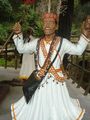
A centre of Buddhist learning and culture, Gangtok's most notable Buddhist institutions are the Enchey monastery, the Do-drul Chorten stupa complex and the Rumtek Monastery. The Enchey monastery is the city's oldest monastery and is the seat of the Nyingma order. The two-hundred-year-old baroque monastery houses images of gods, goddesses, and other religious artifacts. In the month of January, the Chaam, or masked dance, is performed with great fanfare. The Do-drul Chorten is a stupa which was constructed in 1945 by Trulshik Rimpoché, head of the Nyingma order of Tibetan Buddhism. Inside this stupa are complete set of relics, holy books, and mantras. Surrounding the edifice are 108 Mani Lhakor, or prayer wheels. The complex also houses a religious school.
The Rumtek Monastery on the outskirts of the town is one of Buddhism's most sacred monasteries. The monastery is the seat of the Kagyu order, one of the major Tibetan sects, and houses some of the world's most sacred and rare Tibetan Buddhist scriptures and religious objects in its reliquary. Constructed in the 1960s, the building is modeled after a similar monastery in Lhasa, Tibet. Rumtek was the focus of international media attention in 2000 after the seventeenth Karmapa, one of the four holiest lamas, fled Lhasa and sought refuge in the monastery.
The Namgyal Institute of Tibetology, better known as the Tibetology Museum, houses a huge collection of masks, Buddhist scriptures, statues, and tapestries. It has over two hundred Buddhist icons, and is a centre of study of Buddhist philosophy.
The Thakurbari Temple, located in the heart of the city, established in 1935 on a prime piece of land donated by the then Maharaja of Sikkim, is one of the oldest and best-known Hindu temples in the city.
The Ganesh Tok and the Hanuman Tok, dedicated to the Hindu gods Ganpati and Hanuman and housing important Hindu deities, are located in the upper reaches of the city.
The Himalayan Zoological Park exhibits the fauna of the Himalayas in their natural habitats. The zoo features the Himalayan black bear, red pandas, the barking deer, the snow leopard, the leopard cat, Tibetan wolf, masked palm civet and the spotted deer, amongst the others.
Jawaharlal Nehru Botanical Gardens, near Rumtek, houses many species of orchid and as many as fifty different species of tree, including many oaks.
Gallery
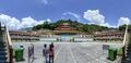
Lingdum Monastery or Rumtek Monastery.
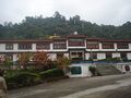
Lingdom Monastry Gangtok
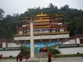
Lingdom Monastry Gangtok
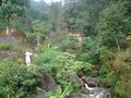
Ban Jakhri Water Falls Park
Ban Jakhri Water Falls Park
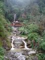
Ban Jakhri Water Falls Park
Ban Jakhri Water Falls Park
Ban Jakhri Water Falls Park
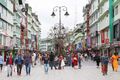
MG Marg (Road) Market
MG Marg (Road) is one of the main shopping and cultural activity streets in Gangtok
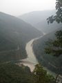
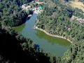
Tista River at Peshok Teas Estate
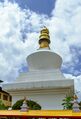
Do-drul Chorten Stupa, Gangtok, Sikkim
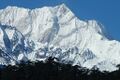
Kangchenjunga East Face from Zemu Glacier
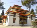
Enchey-Monastery
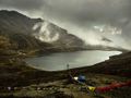
Lake Tsomgo, Sikkim
Lampokhari lake of Aritar, Sikkim


External links
References
- ↑ City Development Plan-Gangtok City. Jawaharlal Nehru National Urban Renewal Mission, Ministry of Urban Development, Government of India.
- ↑ City Development Plan-Gangtok City. Jawaharlal Nehru National Urban Renewal Mission, Ministry of Urban Development, Government of India.
- ↑ Negi, S. S. (1998). Discovering the Himalaya. Indus Publishing. p. 563. ISBN 81-7387-079-9.
- ↑ "Section 2: Introduction To The State And Its Capital" (PDF). City Development Plan-Gangtok City. Jawaharlal Nehru National Urban Renewal Mission, Ministry of Urban Development, Government of India.
- ↑ Shangderpa, Pema Leyda (6 October 2003). "Kids to learn hill state history". The Telegraph.
- ↑ Bernier, Ronald M. (1997). Himalayan Architecture. Fairleigh Dickinson Univ Press. pp. 40–42. ISBN 0-8386-3602-0.
- ↑ "History of Skkim". sikkim.nic.in. National Informatics Center, Sikkim.
- ↑ Jha, Prashant (August 2006). "Special report: A break in the ridgeline". Himal South Asia. South Asia Trust.
- ↑ "Historic India-China link opens". BBC News. 6 July 2006.
- ↑ City Development Plan-Gangtok City. Jawaharlal Nehru National Urban Renewal Mission, Ministry of Urban Development, Government of India.