Sea of Azov
| Author:Laxman Burdak, IFS (R) |


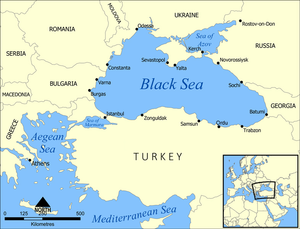
Sea of Azov is a sea in Eastern Europe connected to the Black Sea by the narrow (about 4 km) Strait of Kerch, and is sometimes regarded as a northern extension of the Black Sea.[1][2] The sea is bounded by Russia on the east, by Ukraine on the northwest, and by Crimea on the southwest.
Contents
Variants
- Maeotis Lake (Anabasis by Arrian, p. 202, 203, 274, 370.)
- Azov Sea (Anabasis by Arrian, p. 202, 274.)
- Crimean Tatar: Azaq deñizi;
- Russian: Азовское море,
- romanized: Azovskoye more;
- Ukrainian: Азовське море, romanized: Azovs'ke more)[3]
- Mæotici (Pliny.vi.7)
- Mieotis (Pliny.vi.7)
- Mæotis (Pliny.vi.39)
- Lake Mæotis
- Sea of Azof
- Mæotian lakes (Pliny.vi.1)
- Lake Mæotis (Pliny.vi.15)
Jat Gotras Namesake
- Meo = Mæotici (Pliny.vi.7)
- Meo = Mieotis (Pliny.vi.7)
Jat Gotras Namesake
- Meo = Maeotis Lake (Anabasis by Arrian, p. 202, 203, 274, 370.)
Location
Sea of Azov is a sea in Eastern Europe. To the south it is linked by the narrow (about 4 km ) Strait of Kerch to the Black Sea, and it is sometimes regarded as a northern extension of the Black Sea. The sea is bounded in the north and in the west by Ukraine, in the east by Russia. The Don and Kuban are the major rivers that flow into it. There is a constant outflow of water from the Sea of Azov to the Black Sea.
Maeotis
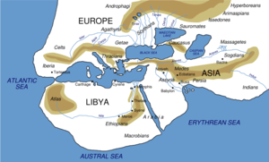
Maeotis was a lake mentioned by Arrian[4] and Pliny[5]. It is the present Sea of Azov.
History
In antiquity, the sea was usually known as the Maeotis Swamp (Ancient Greek: ἡ Μαιῶτις λίμνη, ē Maiōtis límnē; Latin: Palus Maeotis) from the marshlands to its northeast.[6] It remains unclear whether it was named for the nearby Maeotians or if that name was applied broadly to various peoples who happened to live beside it. Other names included Lake Maeotis or Maeotius (Mæotius or Mæotis Lacus);[7] the Maeotium or Maeotic Sea (Mæotium or Mæoticum Æquor);[8] the Cimmerian or Scythican Swamps (Cimmeriae or Scythicæ Paludes);[9] and the Cimmerian or Bosporic Sea (Cimmericum or Bosporicum Mare). The Maeotians themselves were said by Pliny to call the sea Temarenda[10] or Temerinda, meaning "Mother of Waters".[11]
Mention by Pliny
Pliny[12] mentions The Cimmerian Bosporus....The length of the peninsula1 which projects between the Euxine and Lake Mæotis, is not more than sixty-seven miles and a half, and the width across never less than two jugera:2 it has the name of Eion.3 The shores of the Bosporus then take a curve both on the side of Europe and of Asia, thus forming the Mæotis.
1 The peninsula on which Taman or Timoutarakan is situate.
2 The jugerum was 100 Grecian or 104 Roman feet in length.
3 Signifying in Greek the "sea-shore."
Mention by Pliny
Pliny[13] mentions Lake Mieotis and the adjoining nations....We then come to the river Tanais3, which discharges itself into the sea by two mouths, and the banks of which are inhabited by the Sarmatæ, the descendants of the Medi, it is said, a people divided into numerous tribes. The first of these are the Sauromatæ Gynæcocratumeni4 the husbands of the Amazons.
3 Or Don. It flows into the Sea of Azof by two larger mouths and several smaller ones. Strabo says that the distance between the two larger mouths is sixty stadia. several smaller ones. Strabo says that the distance between the two larger mouths is sixty stadia.
4 From the Greek γυναικοκρατουμενοὶ, "ruled over by women." It is not improbable that this name was given by some geographer to these Sarmatian tribes on finding them, at the period of his visit, in subjection to the rule of a queen. Parisot remarks, that this passage affords an instance of the little care bestowed by Pliny upon procuring the best and most correct information, for that the Roman writers had long repudiated the use of the term "Sauromatæ." He also takes Pliny to task for his allusion to these tribes as coupling with the Amazons, the existence of such a people being in his time generally disbelieved.
Mention by Pliny
Pliny[14] mentions Lake Mieotis and the adjoining nations.... There are some writers who state that there are the following nations dwelling around the Mæotis, as far as the Ceraunian mountains;13 at a short distance from the shore, the Napitæ, and beyond them, the Essedones, who join up to the Colchians, and dwell upon the summits of the mountains:
13 The Ceraunian mountains were a range belonging to the Caucasian chain, and situate at its eastern extremity; the relation of this range to the chain has been variously stated by the different writers.
External links
References
- ↑ "Sea of Azov". Encyclopædia Britannica.
- ↑ https://www.worldatlas.com/seas/sea-of-azov.html
- ↑ Adyghe: Хы мыутӏэ, romanized: Xı mıut’ə; Crimean Tatar: Azaq deñizi
- ↑ Arrian:The Anabasis of Alexander/3b, Ch.30
- ↑ Natural History by Pliny Book VI/Chapter 6
- ↑ James, Edward Boucher (1857). "Maeotae and Maeotis Palus". In Smith, William. Dictionary of Greek and Roman Geography. 2 (1st ed.). London: Walton & Maberly.
- ↑ Pliny the Elder. Naturalis Historiæ ["Natural History"], iv.24 & vi.6. (in Latin)
- ↑ Gaius Valerius Flaccus. Argonautica. iv.720. (in Latin)
- ↑ Publius Ovidius Naso. Her.[which?] vi.107. & Trist.[which?] iii.4.49
- ↑ Baynes, T.S., ed. (1878). "Sea of Azoff". Encyclopædia Britannica. 3 (9th ed.). New York: Charles Scribner's Sons. p. 169.
- ↑ Pliny the Elder. Naturalis Historiæ ["Natural History"], vi.7.
- ↑ Natural History by Pliny Book VI/Chapter 6
- ↑ Natural History by Pliny Book VI/Chapter 7
- ↑ Natural History by Pliny Book VI/Chapter 7