Safeid Koh
| Author:Laxman Burdak, IFS (R) |
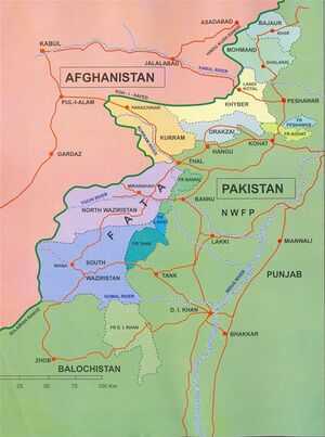
Safeid Koh (Persian: سفید کوه, Urdu: سفید کوہ, "White Mountains"; also known as Spin Ghar (Pashto: سپين غر, "white mountain", the Indian Caucasus as late as the 19th century, the Safīd Mountain Range and as the Morga Range, is a mountain range in eastern Afghanistan and expanding well to North-Western Pakistan.
Variants of name
- Caucasus
- Koh-i-Safed
- Safēd Kōh
- Safīd Mountain
- Spin Ghar
- Shvetaparvata (श्वेतपर्वत) (Mahabharata) (II.25.1), (IX.36.20),
- White Mountains
Location
Its highest peak, straight and rigid Mount Sikaram, towers above all surrounding hills to 4,761 m above mean sea level. The Kabul River cuts a narrow trough through the Safēd Kōh mountains to flow eastward into the Indus River; otherwise, the range connects directly with the Shandur Top offshoot of the Hindu Kush mountain system.[1]
The Khyber Pass crosses a spur of the Safēd Kōh range. The closest city near the Safed Koh is Parachinar of Pakistan.
History
Above the nearly barren lower slopes, forests of pine and deodar cedar thrived on the main range, but devastation during the Afghan civil war reduced timber resources. The valleys still support some agriculture.
Notable persons
External links
References
- ↑ Safīd Mountain Range in Encyclopaedia Britannica, 2009
Back to Jat Places in Pakistan
