Singhbhum
| Author:Laxman Burdak, IFS (Retd.) |


Singhbhum (सिंहभूम) was a district of India during the British Raj and formed a part of the Chota Nagpur Division of the Bengal Presidency. The district has in recent decades been divided into three smaller districts: 1. East Singhbhum, 2. West Singhbhum and 3. Saraikela Kharsawan. All the three are currently part of Jharkhand state of India. It is included in Kolhan division. Author visited the place on 18.1.1981.
Contents
Variants
- Sinhabhuma सिंहभूम, बिहार, (AS, p.963)
Location
It is located in the present-day Indian state of Jharkhand. Chaibasa is the district headquarters. Located in the southern limit of the Chota Nagpur Plateau, Singhbhum included the Kolhan estate located in its southeastern part.
Singhbhum Craton
Singhbhum Craton, 4,000 km2 area which primarily covers Jharkhand as well as parts of Odisha, northern Andhra Pradesh, northern Telangana and eastern Maharashtra. It is limited by the Chhota Nagpur Plateau to the north, Eastern Ghats to the southeast, Bastar Craton to southwest and alluvium plain to the east.
Cratons are a specific kind of continental crust made up of a top layer called platform and an older layer called basement. A shield is the part of a craton where basement rock crops out of the ground, and it is relatively the older and more stable section, unaffected by plate tectonics
History
Kirana Suvarna was one of Buddhist Kingdoms visited by Xuanzang in 639 AD. Kirana Suvarna has been identified with Barabhum in Purulia district of West Bengal by Alexander Cunningham[1]
Alexander Cunningham[2] writes that Hwen Thsang places the capital of Kie-lo-na-su-fa-la-na, or Kirana Suvarna, at 700 li, or 117 miles, to the north-west of Tamralipti, and the same distance to the north-east of Odra or Orissa.[3] As the capital of
[p.505]: Orissa in the seventh century was Jajipur on the Vaitarani river, the chief city of Kirana Suvarna must be looked for along the course of the Suvarna-riksha river (Subarnarekha), somewhere about the districts of Singhbhum and Barabhum. But this wild part of India is so little known that I am unable to suggest any particular place as the probable representative of the ancient capital of the country. Bara Bazar is the chief town in Barabhum, and as its position corresponds very closely with that indicated by Hwen Thsang, it may be accepted as the approximate site of the capital in the seventh century. The territory was from 4400 to 4500 li, or from 733 to 750 miles, in circuit. It must, therefore, have comprised all the petty hill- states lying between Medinipur and Sirguja on the east and west, and between the sources of the Damuda and Vaitarani on the north and south.
This large tract of country is now occupied by a number of wild tribes who are best known by the collective name of Kolhan or Kols. But as the people themselves speak various dialects of two distinct languages, it would appear that they must belong to two different races, of whom the Munda and the Uraon may be taken as the typical representatives. According to Colonel Dalton,[4] "the Mundas first occupied the country and had been long settled there when the Uraons made their appearance;" and "though these races are now found in many parts of the country occupying the same villages, cultivating the same fields, celebrating together the same festivals and enjoying the same amusements, they are of totally distinct origin, and cannot intermarry without loss of caste." This
[p.506]: difference of race is confirmed by the decisive test of language, which shows that the Uraons are connected with the Tamilian races of the south, while the Mundas belong to the hill men of the north, who are spread over the Himalayan and Vindhyan mountains from the Indus to the Bay of Bengal.
The various tribes connected with the Mundas are enumerated by Colonel Dalton[5] as the Kuars of Elichpur, the Korewas of Sirguja and Jaspur, the Kherias of Chutia Nagpur, the Hor of Singhbhum, the Bhumij of Manbhum and Dhalbhum, and the Santals of Manbhum, Singhbhum, Katak, Hazaribagh, and the Bhagalpur hills. To these he adds the Juangas or Pattuns (leaf-clad) of Keunjar, etc. in the Kataka tributary districts, who are isolated from " all other branches of the Munda family, and have not themselves the least notion of their connection with them ; but their language shows that they are of the same race, and that their nearest kinsmen are the Kherias. The western branches of this race are the Bhils of Malwa and Kanhdes, and the Kolis of Gujarat. To the south of these tribes there is another division of the same race, who are called Suras or Suars. They occupy the northern end of the eastern Ghats.
According to Dr Naval Viyogi, It seems from the evidence of Puri Kushan coins that some branch Tanka of Taka royal family owing to attack of Kushanas up to Magadha, reached Mayurbhanj, Singhbhumi, Ganjam and Balasore and established colonies there, where remains of their offshoot, the royal family of Dhavaldev is still existing at Dalbhumigarh near Kharagpur. [6]
Jat History
We find large number of places in Orissa and Singhbhum area of Jharkhand areas based on Jat clans. Here is a partial list of Jat clans.
Why Tak Jats moved to Eastern Coast ?
Puri Kushan (पुरी कुषाण), properly called Imitation Kushan, are copper coins discovered in the littoral districts of Ganjam, Puri, Cuttack, Bhadrakand Balasore as well as hill districts in of Mayurbhanj and Keonjhar in Orissa; Ranchi and Singhbhum in Bihar and a few in Andhra Pradesh and West Bengal.[7]
B S Dahiya[8] writes: Tanks or Taks are mentioned by Col. Tod as one of the Thirty –six royal houses of Indian Kshatriyas, but he said about them that they have disappeared from history owing to their conversion to Islam in the Thirteenth Century. But this is not true because they have not disappeared completely as yet; it is true a large number of Tanks are now followers of Islam but there still exist many Tanks among the Hindu Jats also. [9]
A Tak kingdom is mentioned by Hiuen-Tsang (631-643 A.D.). It is mentioned by him as situated towards east of Gandhara. Hiuen-Tasng gives its name as Tekka, and the History of Sindh, Chach-Nama, mentions it as Tak. Its capital was Shekilo (Sakala, modern Sialkot) and formerly King Mihiragula was ruling from this place. In seventh century A.D. its people were not preeminently Buddhists, but worshiped the sun, too. Abhidhana Chintamani says that Takka is the name of Vahika country (Punjab). For what follows, we are indebted to Chandrashekhar Gupta for his article on Indian coins. [10] The Tanks must have come to India, Prior to fourth century A.D. i.e. with the Kushana. And with the Kushanas, they must have spread up to Bengal and Orissa, like the Manns and Kangs who spread into southern Maharashtra and the Deccan. In Orissa, the Tanks, had their rule in Orissa proper, Mayurbhanj, Singbhoom, Ganjam, and Balasore Districts. They are called by historians as “ Puri Kushans” or Kushanas of Puri (Orissa). Their coins have been found at Bhanjakia and Balasore (Chhota Nagpur) and these coins have the legend Tanka written in Brahmi script of the fourth century A.D. Allan suggested the reading Tanka as the name of a tribe “ [11] and others generally accepted the reading Tanka as correct. [12] Allan placed them in the third or early fourth century A.D., while V.A. Smith placed them in the fourth or fifth century A.D. ; R.D. Bannerji called them “ Puri Kushanas” [13]
Dr Naval Viyogi [14] tells that it is not improper to assume that probably these people migrated from the North-West Region of India to the Eastern Coastal area for some unknown reasons. Probably this was due to some political pressure or economic causes. In the vast region comprising - Orissa, Mayurbhanj, Singhbhumi, Ganjam and Balasore districts, they established their colonies. This is supported by the findings of the so called 'Puri Kushan' copper coins from this area.
Dr Naval Viyogi [15] writes that it seems from the evidence of Puri Kushan coins that some branch Tanka of Taka royal family owing to attack of Kushanas up to Magadha, reached Mayurbhanj, Singhbhumi, Ganjam and Balasore and established colonies there, where remains of their offshoot, the royal family of Dhavaldev is still existing at Dalbhumigarh near Kharagpur.
As for the proof that they were Jats, we invite attention to the fact that they still exist as such. Their association with the Kushanas (Kasvan Jats) further supports it. Their central Asian origin is proved by the fact that Niya Khrosthi documents from Central Asia refer to coin denomination as Tangumule. [16] Here the word Tanga is the same as Tanka, and Muli meant “Price” in Central Asia. [17]
सिंहभूम
सिंहभूम (AS, p.963): यह जिला छोटा नागपुर के अंतर्गत स्थित है. मयूरभंज के निकट बागनमती में रोम सम्राट कांस्टेंटाइन के स्वर्ण के सिक्के मिले थे जिससे यह सूचित होता है कि प्राचीन काल में ताम्रलिप्ति के बंदरगाह से एक व्यापारिक मार्ग यहां होकर उत्तर की ओर जाता था. बेनीसागर नामक स्थान पर 9-10वीं सदी के मंदिरों के अवशेष हैं. सिंहभूम जिले में तांबे के सिक्के बनाने के कारखाने थे. [18]
छोटा नागपुर
छोटा नागपुर (AS, p.349)- इस प्रदेश का नाम, किवदंती के अनुसार, छोटानाग नामक नागवंशी राजकुमार-सेनापति के नाम पर पड़ा है. छोटानाग ने, जो तत्कालीन नागराजा का छोटा भाई था, मुगलों की सेना को हराकर अपने राज्य की रक्षा की थी. सरहूल की लोककथा छोटानाग से संबंधित है. इस नाम की आदिवासी लड़की ने अपने प्राण देकर छोटानाग की जान बचाई थी. सर जॉन फाउल्टन का मत है कि छोटा या छुटिया रांची के निकट एक गांव का नाम है जहां आज भी नागवंशी सरदारों के दुर्ग के खंडहर हैं. इनके इलाके का नाम नागपुर था और छुटिया या छोटा इसका मुख्य स्थान था. इसीलिए इस क्षेत्र को छोटा नागपुर कहा जाने लगा. (देखें: सर जॉन फाउल्टन - बिहार दि हार्ट ऑफ इंडिया, पृ. 127) छोटा नागपुर के पठार में हजारीबाग, रांची, पालामऊ, मानभूम और सिंहभूम के जिले सम्मिलित हैं.
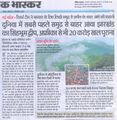
झारखंड के सिंहभूम में समुद्र से पहली बार बाहर निकली थी धरती
दुनिया में सबसे पहले समुद्र से बाहर कौन सा द्वीप बाहर आया? अब तक हम सब यही मानते रहे कि सबसे पहले अफ्रीका और ऑस्ट्रेलिया समुद्र से बाहर आए, लेकिन अब नई रिसर्च में सामने आया है कि झारखंड में सिंहभूम जिला समुद्र से बाहर आने वाला दुनिया का पहला जमीनी हिस्सा है। 3 देशों के 8 रिसर्चर्स 7 साल की रिसर्च के बाद इस नतीजे पर पहुंचे हैं। यह क्षेत्र उत्तर में जमशेदपुर से लेकर दक्षिण में महागिरी तक, पूर्व में ओडिशा के सिमलीपाल से पश्चिम में वीर टोला तक फैला हुआ है। इस क्षेत्र को हम सिंहभूम क्रेटान (महाद्वीप) कहते हैं।[19]
अमेरिका के विज्ञान के चर्चित जर्नल 'प्रोसिडिंग्स ऑफ द नेशनल एकेडमी आफ साईंस (पीएनएएस)' में पिछले सप्ताह प्रकाशित एक शोध के मुताबिक़, आज से 310 करोड़ साल पहले सिंहभूम क्रेटोन (महाद्वीप) का जन्म हुआ, यानी यह क्षेत्र पहली बार पानी से बाहर आया. उस समय ज़मीन का अस्तित्व समुद्र के अंदर हुआ करता था. लेकिन, धरती के 50 किलोमीटर भीतर हुए एक बड़े ज्वालामुखी विस्फोट के कारण पृथ्वी का यह हिस्सा (सिंहभूम क्रेटोन) समुद्र से बाहर आ गया. इस शोध में भारतीय मूल के चार शोधकर्ता डॉ. प्रियदर्शी चौधुरी, सूर्यजेंदु भट्टाचार्यी, शुभोजीत राय और शुभम मुखर्जी शामिल हैं. [20]
Gallery
दुनिया में सबसे पहले समुद्र से बाहर आया झारखंड का सिंहभूम द्वीप

See also
External links
References
- ↑ The Ancient Geography of India/Eastern India, p.505
- ↑ The Ancient Geography of India/Eastern India, p.505
- ↑ Julien 's 'Hiouen Thsang,' iii.84 and 88. See Map No. I.
- ↑ Journ. Asiat. Soc. Bengal, 1866, p. 154.
- ↑ Journ. Asiat. Soc. Bengal, 1866, 158. I write Santal in preference to Sonthal, as I believe that the short o is only the peculiar Bengali pronunciation of the long ā.
- ↑ Dr Naval Viyogi: Nagas – The Ancient Rulers of India, p.158
- ↑ 'Newly Found Imitation Kushan Coin Hoard From Dolashai, Bhadrak Orissa' by Ajay Kumar Nayak
- ↑ Jats the Ancient Rulers (A clan study)/Jat Clan in India,p. 273-274
- ↑ Bhim Singh Dahiya, Jats the Ancient Rulers ( A clan study), p. 274
- ↑ Vishveshvaranand Indological Journal (Hoshiarpur, Pb.) Vol, XVI, pt. I. p.92 ff
- ↑ Ancient India, Plate XII, fig. 3
- ↑ Journal of Numismatic Society of India, 12, 1950 p.72
- ↑ Bhim Singh Dahiya, Jats the Ancient Rulers ( A clan study), p. 274
- ↑ Dr Naval Viyogi: Nagas – The Ancient Rulers of India, p.157
- ↑ Dr Naval Viyogi: Nagas – The Ancient Rulers of India, p.158
- ↑ ibid., 16-1954 p. 220 f.n. 4
- ↑ Bhim Singh Dahiya, Jats the Ancient Rulers ( A clan study), p. 274
- ↑ Aitihasik Sthanavali by Vijayendra Kumar Mathur, p. 963
- ↑ bhaskar.com, 13.12.2021
- ↑ Source: https://www.bbc.com/hindi/india-59325568
Back to Jharkhand