Surguja
| Author:Laxman Burdak, IFS (R) |
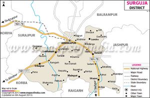
Surguja (सरगुजा) is a town and district in Chhattisgarh. The district headquarters is Ambikapur.
Contents
Variants
- Sarguja
- Dandora (दाण्डोर)/Bâis Dândôr/Bais Dandor (बाईस डांडोर) mentioned in Rajim Stone Inscription of Prithvideva II - Kalachuri Year 896 (=1145 AD). Dandora (दाण्डोर) may be identified with the former State of Sarguja which was once called Bâis Dândôr (बाईस डांडोर) as it included twenty-two zamindaris. (p,453) [1]
Jat Gotras Namesake
- Dandor (Jat clan) = Dandora (दाण्डोर)/Bâis Dândôr/Bais Dandor (बाईस डांडोर) mentioned in verse -5 of Rajim Stone Inscription of Prithvideva II - Kalachuri Year 896 (=1145 AD).... (V. 5) The son of Svâmin (स्वामि), Jayadêva (जयपाल) by name, a great warrior, acquired Dandora (दाण्डोर) including twenty-one hundred villages. Dandora (दाण्डोर) may be identified with the former State of Sarguja which was once called Bâis Dândôr (बाईस डांडोर) as it included twenty-two zamindaris. (p,453) [2]
Location
It lies between 23°37'25" to 24°6'17" north latitude and 81°34'40" to 84°4'40" east longitude. There are three river basins in Suguja district – those of the Hasdeo River, the Rihand River and the Kanhar River. The district lies in its eponymous Surguja dialectal region (where Surgujia is spoken) and is to the east of the Vindhyachal-Baghelkhand region of peninsular India.
Tahsils in Surguja district
History
According to legend, Lord Rama had visited Surguja during his 14 years of exile into the forests. There are many places in connection to epic of Ramayana, which are named after Lord Rama, Laxmana and Goddess Sita such as Ramgarh, Sita-Bhengra and Laxmangarh.[3]
Prior to the arrival of the Mauryas, the area was ruled by the Nandas. In the third century BC the region was divided into tiny kingdoms. Later, a Rajput king belonging to the Rakshal clan attacked from what is now Jharkhand, and took control of the area.
In 1613, a Rajput king belonging to the Rakshal clan attacked from Palamu in what is now Jharkhand, and took control of the area.
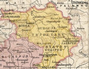
In 1753, the Marathas invaded Surguja and forced the king to become a vassal. After the Third Anglo-Maratha War in 1818, the British gained control of the three princely states of Surguja, Koriya and Changbhakar. In 1820, Amar Singh was crowned as Maharaja. During the British Raj period, Surguja State was a princely state. [4]
In 1820, Amar Singh was crowned as Maharaja. During the British Raj period, Surguja State was a princely state.
In 1951, Surguja became part of the new state of Madhya Pradesh. In 2000, it was one of the districts in the new state of Chhattisgarh.
Languages: Languages spoken include Surgujia, Nagpuri, Bharia, a Dravidian vernacular spoken by at least 200,000 members of the Bharia tribe.[5]
People
The district spread over a vast mountainous area inhabited by many different people groups such as the Gond, Bhumij, Oraon, Panika, Korwa, Bhuiya, Kharwar, Munda, Chero, Rajwar, Nagesia, Kanwar and Santal.
Notable persons
External links
References
- ↑ Corpus Inscriptionium Indicarium Vol IV Part 2 Inscriptions of the Kalachuri-Chedi Era, Vasudev Vishnu Mirashi, 1955, p.450-457
- ↑ Corpus Inscriptionium Indicarium Vol IV Part 2 Inscriptions of the Kalachuri-Chedi Era, Vasudev Vishnu Mirashi, 1955, p.450-457
- ↑ https://surguja.gov.in/
- ↑ https://surguja.gov.in/
- ↑ M. Paul Lewis, ed. (2009). "Bharia: A language of India". Ethnologue: Languages of the World (16th ed.). Dallas, Texas: SIL International.
Back to Chhattisgarh

