Umarkot Orissa
| Author:Laxman Burdak, IFS (R) |
Umerkote (Hindi: उमरकोट, Odia: ଉମରକୋଟ), also known as Umarkot and Amarkot, is a town of Nabarangpur district, Odisha, in eastern India.
Origin
The District of Koraput derives its name from its headquarters, the present town of koraput. In ancient times, when the Nalas were ruling over this tract, Pushkari, the modern Umerkote was the capital city.[1]
Location
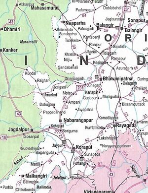
Umerkote is situated in the northern corner of Nabarangpur District and administratively borders Chhattisgarh in the west. It is 62 km away from district headquarters. A left diversion from National Highway 201 at Papadahandi, towards Raipur, connects to Umerkote.
The place is presided over by the local deity Maa Pendrani or Pendrahandiani. The word "Maa" means the "mother". She is believed to be the saviour of people living and provider of health, wealth and protection.
Geography
A plateau of the Kondan Range, a terrain of Eastern Ghats holds Umerkote at its centre. The average elevation of Umerkote is approximately 620 metres (2,020 ft) above sea level. Small hills and mounts cover the place, providing a number of perennial sources of water as streams and ponds. Bhaskel Minor Irrigation Project, a site 9 km (6 miles) away from Umerkote town, is the source of irrigation. Its out-stream, namely Bhaskel, flows by the town, giving a production of vegetables and pulses throughout the year.
Branches of the main canals of the Bhaskel Minor Irrigation Project surround the outskirts of Umerkote to give up a fertile land for double crops and other seasonal productions.
People
Umerkote was initially a tribal-dominated place, and the post-independent period added migrants to its population. With growth, township people from other parts of Odisha and neighbouring states showed their interest to live at Umerkote. People there mostly do business, and a considerable number are government employees. Now the place has a majority of Hindus. However, Muslims are more in number than the Christians. People of other religions are very few in number. The major language spoken in this region is Odia. The Odisha Government sheltered large numbers of Bangladeshi refugees in this region. They came to India as refugees during the 1960s. Umerkote was included in the D.N.K. project under the Government of India.
History
Koraput/Nabarangpur belonged to the Atavikas, a feudatory of the powerful Kalinga Empire (Ancient Odisha) who valiantly fought the Kalinga War in the 3rd century BCE. Kalinga regained its former glory during the Mahameghabahan Dynasty in the first century BCE. The third king of this dynasty Kharavela made the Kalinga empire and the Atavika land was very strong under his rule.
The successive dynasties – the Satavahanas (2nd century CE), Ikshvakus (3rd century CE) had headquarters at Pushkari, near the modern town of Umerkote. The Kesaribeda excavations bear testimony to the rule of King Bhabadatta Varma and King Arathapati. The inscriptions of Podagarh refer to king Skandavarma.
In the 4th or 5th century CE the Nala dynasty, with their headquarters in Pushkari near Umerkote, took control of the entire Bastar-Koraput region. The ruins of large temples and land grants indicate extensive civilizational development in the area. The Nalas fought several wars with the Vakatakas, the first of which they won handily and the second of which Pushkari was destroyed. Nala power was briefly restored by Skanda Varman, who rebuilt Pushkari, but was soon swept away by the Chalukyas. At the end of the 5th century CE, the Eastern Gangas came to control the area, but this period is little-known.[2]
Podagad, a hill range in the west of the town preserves some historic evidences of ancient dynasties ruling over the area. Rock scriptures, caves and remains of usables have been found. It has a rich ruin of the Nala and Bhakataka dynasty during the invasion of the Mughals.
Later it has been occupied by some Buddhists, and then by the Nanda Dynasty of Jeypore region. It is roughly 22 kms towards the west of Umerkote, near Dhodra, a small village which is 9 km ahead of Umerkote. The span of Podagad hill ranges 11 km lengthwise and 3.5 km in width. It was 17 small hills meshed up with each other. It has a natural habitat covering many species, and formerly there were many carnivores living in the area. Deforestation for firewood and timber has been devastating the climate of Podagad. Picnic occasions are held at this place in a massive manner during New Years and other winter days.
Chandan Dhara: Chandan Dhara is a nature area with scenic beauty situated in the deep forests 48 kilometres north of Umerkote, through the village Jharigam. There is a waterfall nearby to the small village Dongriguda. Administrative efforts have been initiated to make it a place of attraction for tourists.
Burja: Burja is about 8 kms from Umerkote, famous for the Siva Mandir. A Siva Linga was discovered by a small girl while she was digging in the field circa 2004. A big temple is now under construction.
References
- ↑ https://koraput.nic.in/history/
- ↑ "ODISHA DISTRICT GAZETTEERS: NABARANGPUR" (PDF).
Back to Orissa
