Gaziura
| Author:Laxman Burdak, IFS (R) |

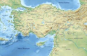
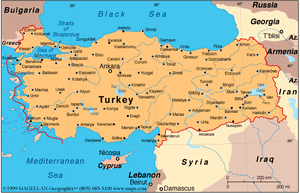
Gaziura (Greek: Γαζίουρα), was a town in Pontus, on the river Iris in northern Turkey, near the point where its course turns northwards. Some scholars equate Gaziura with Talaura,[1] others with Ibora,[2] and others with modern Turhal.[3] It has been suggested that the modern Azurnis occupies its site. [4]
Variants
Jat clans
History
It was the ancient residence of the kings of Pontus, but in Strabo's time it was deserted. (Strab. xii.) Dion Cassius (xxxv. 12) notices it as a place where Mithridates VI of Pontus took up his position against the Roman Triarius. (Comp. Pliny vi. 2.)
Mention by Pliny
Pliny[5] mentions...We then come to the river Evarchus13, and after that a people of the Cappadocians, the towns of Gaziura14 and Gazelum15, the river Halys16, which runs from the foot of Mount Taurus through Cataonia and Cappadocia, the towns of Gangre17 and Carusa18, the free town of Amisus19, distant from Sinope one hundred and thirty miles, and a gulf of the same name, of such vast extent20 as to make Asia assume the form of a peninsula, the isthmus of which is only some two hundred21 miles in breadth, or a little more, across to the gulf of Issus in Cilicia. In all this district there are, it is said, only three races that can rightly be termed Greeks, the Dorians, the Ionians, and the Æolians, all the rest being of barbarian origin.22 To Amisus was joined the town of Eupatoria23, founded by Mithridates: after his defeat they were both included under the name of Pompeiopolis.
14 On the river Iris. It was the ancient residence of the kings of Pontus, but in Strabo's time it was deserted. It has been suggested that the modern Azurnis occupies its site.
15 In the north-west of Pontus, in a fertile plain between the rivers Halys and Amisus. It is also called Gadilon by Strabo. D'Anville makes it the modern Aladgiam; while he calls Gaziura by the name of Guedes.
16 Now called the Kisil Irmak, or Red River. It has been remarked that Pliny, in making this river to come down from Mount Taurus and flow at once from south to north, appears to confound the Halys with one of its tributaries, now known as the Izchel Irmak.
17 Its site is now called Kiengareh, Kangreh, or Changeri. This was a town of Paphlagonia, to the south of Mount Olgasys, at a distance of thirty-five miles from Pompeiopolis.
18 A commercial place to the south of Sinope. Its site is the modern Gherseh on the coast.
19 Now called Eski Samsun; on the west side of the bay or gulf, anciently called Sinus Amisenus. According to Strabo, it was only 900 stadia from Sinope, or 112 1/2 Roman miles. The walls of the ancient city are to be seen on a promontory about a mile and a half from the modern town.
20 He means the numerous indentations which run southward into the coast, from the headland of Sinope to a distance of about one degree to the south.
21 On examining the map, we shall find that the distance is at least 300 miles across to the gulf of Issus or Iskenderoon.
22 Not speaking the Greek language.
23 A part of it only was added to Eupatoria; and it was separated from the rest by a wall, and probably contained a different population from that of Amisus. This new quarter contained the residence of the king, Mithridates Eupator, who built Eupatoria.
References
- ↑ E.g., William Smith
- ↑ E.g., Catholic Encyclopedia
- ↑ E.g., Richard Talbert, Barrington Atlas of the Greek and Roman World, (ISBN 0-691-03169-X), Map 87 & notes.
- ↑ Natural History by Pliny Book VI/Chapter 2, f.n.14
- ↑ Natural History by Pliny Book VI/Chapter 2
Back to Jat Places in Turkey/Back to Jat Places in Anatolia
