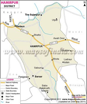
Hamirpur Himachal Pradesh
- Note - Please click → Hamirpur for details of similarly named villages at other places.
Hamirpur (हमीरपुर) is a district town in Himachal Pradesh.
Origin of name
Raja Hamir Chand (r. 1700 - 1740) built the fort at Hamirpur and the present town derived its name from this ruler.
Location
Hamirpur District is situated between 31°25′N and 31°52′N and between 76°18′E and 76°44′E. Situated at an altitude of 785 meters.
Administrative Divisions
The district comprises 4 sub-divisions: Hamirpur, Barsar, Nadaun and Bhoranj.
Hamirpur sub-division consists 2 tehsils: Hamirpur and Sujanpur. Barsar, Nadaun and Bhoranj sub-divisions comprise only one tehsil: Barsar, Nadaun and Bhoranj respectively.
Jat gotras
हिमाचल के हमीरपुर के कई हिस्सों में जाट समुदाय के लोग हैं। [1]
Jat Villages
History
Carved out from the Kangra district in 1972, the district is closely associated with the Katoch dynasty. It was the part of old Jalandhar-Trigarta empire. Panini referred to the people of this kingdom as great warriors and fighters. Even today Army is the largest employer for Hamirpuris, who form large bulks of Dogra Regiment, Jammu and Kashmir Rifles regiment as well as Hodson's Horse and Scinde Horse. In addition to their repute for being brave and professional soldiers they are well known for the hardiness characteristic of hill people thus earning the name Veer Bhumi for Hamirpur as rest of Himachal calls itself Dev Bhumi.
The Katoch dynasty predominated during the period of Raja Hamir Chand who ruled from 1700 to 1740. It was Raja Hamir Chand who built the fort at Hamirpur and the present town derived its name from this ruler.
External links
It's official website is: http://hphamirpur.nic.in
References
Back to Jat Villages
