Jatawar
| Author:Laxman Burdak, IFS (R) |

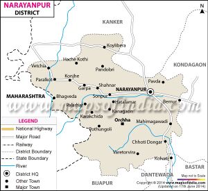
Jatawar (जाटवर) is a village Orchha tahsil of Narayanpur district in Chhattisgarh. It is part of Abujhmar.
Variants
Jat Gotras Namesake
- Jat = Jatawar, a village Orchha tahsil of Narayanpur district in Chhattisgarh. It is part of Abujhmar.
Origin
Location
It is located 44 KM towards South from District head quarters Narayanpur.
According to Census 2011 information the location code or village code of Jatawar village is 449853. Jatawar village is located in Orchha tehsil of Narayanpur district in Chhattisgarh, India. It is situated 121km away from sub-district headquarter Orchha (tehsildar office) and 65km away from district headquarter Narayanpur. As per 2009 stats, Ghamandi is the gram panchayat of Jatawar village. Jatawar has a total population of 52 peoples, out of which male population is 22 while female population is 30. There are about 11 houses in jatawar village. Pincode of jatawar village locality is 494661. Narayanpur is nearest town to jatawar for all major economic activities, which is approximately 65km away.[1]
Jatawar is a small Village/hamlet in Orchha (abhujmad) Tehsil in Narayanpur District of Chattisgarh State, India. It comes under Jatawar Panchayath. It is located 44 KM towards South from District head quarters Narayanpur. 247 KM from State capital Raipur. Jatawar is surrounded by Narayanpur Tehsil towards North , Bhairamgarh Tehsil towards South , Geedam Tehsil towards South , Bhamaragad Tehsil towards west . Kondagaon , Bade Bacheli , Jagdalpur , Kanker are the near by Cities [2]
