Pandaripani
| Author:Laxman Burdak, IFS (R) |

Pandaripani (पंडरीपानी) is village in Bodla tahsil of Kawardha (Kabirdham) district in Chhattisgarh.
Variants
Jat Gotras Namesake
- Pandar = Pandaripani village in Bodla tahsil of Kawardha (Kabirdham) district in Chhattisgarh.
Origin
Location
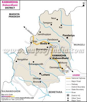
It is situated 84km away from sub-district headquarter Bodla (tehsildar office) and 104km away from district headquarter Kawardha. According to Census 2011 information the location code or village code of Pandaripani village is 439502. Pandaripani village is located in Bodla tehsil of Kabeerdham district in Chhattisgarh, India. The total geographical area of village is 226.44 hectares. [1]
Pandhripani is a Village in Bodla Tehsil in Kabirdham District of Chattisgarh State, India. It is located 20 KM towards North from District head quarters Kawardha. 129 KM from State capital Raipur. Pandhripani Pin code is 491888 and postal head office is Gandai Pandaria . Pandhripani is surrounded by Kabirdham Tehsil towards South , Kawardha Tehsil towards South , Pandariya Tehsil towards East , S.Lohara Tehsil towards South .[2]
History
Population
Pandaripani has a total population of 294 peoples, out of which male population is 138 while female population is 156. Literacy rate of pandaripani village is 27.55% out of which 27.54% males and 27.56% females are literate. There are about 77 houses in pandaripani village. Pincode of pandaripani village locality is 496445. [3]
