
Tirathgarh
| Author:Laxman Burdak, IFS (R) |


Tirathgarh (तीरथगढ) is town in Darbha tahsil in Bastar district in Chhattisgarh, India. It is known for Tirathgarh Waterfalls. Tirathgarh also contains some temples and relics. Author (Laxman Burdak) visited Tirathgarh on 25.09.1982, 04.10.1982, 24.10.1982, 02.01.1983, 11.01.1983.
Variants
Location
It is situated 5km away from sub-district headquarter Darbha (tehsildar office) and 35 km away from district headquarter Jagdalpur. According to Census 2011 information the location code or village code of Tirathgarh village is 449618. Tirathgarh village is located in Darbha tehsil of Bastar district in Chhattisgarh, India. As per 2009 stats, Tirathgarh village is also a gram panchayat. The total geographical area of village is 1376.65 hectares.[1]
Tirathgarh Waterfalls

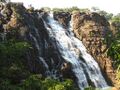
Tirathgarh Waterfalls: Tirathgarh, 35 Km from Jagdalpur is famous for this waterfall that drops into Mugabahar river. On descending down the steps you can get a grand view of the falling sheets of water that falls from a height of 50 metres. There is also an old Shiva -Parvati temple at the site. You can go up the watchtower to enjoy the panoramic view of the waterfalls and surrounding forests. Waterfalls abound and range from zig-zag trickles to roaring falls.
Smaller waterfalls include Kanger Dhara near Kutumsar, Mandra, Chitradhara, Tamada and Dhoomar.
Although smaller, each one surrounded with greenery is a treat to the eyes.
Tirathgarh Waterfalls can be termed as "Milky Fall" because of the white colour of the water as it descends down the rocky slope giving an impression as if milk is falling.
It is located around 35 km from Jagdalpur in the renowned eco tourism site of Kanger Valley National Park. The Tirathgarh Falls is one of the most visited waterfalls in Chhattisgarh. Splashing streams of water come down at speed from a height of more than 100 feet on the river Mugabahar which originates in a lake not very far away from this point. The area surrounding the fall features green forests.
The water flowing through the various streams and crossing numerous paths along the way in a zigzag manner and finally ending up in the falls is a treat to watch. Besides the natural environment associated with this place, Tirathgarh Falls is also an important religious place featuring a temple which is dedicated to Shiva- Parvati. Every year, thousands of tourists and devotees come here from within the state and across India for the views of Tirathgarh Falls as well as to offer prayers at the temple. The best season to visit this place is in the months of October through February.[2]
History
Tirathgarh contains some temples and relics.[3]
Population
Tirathgarh has a total population of 1,484 peoples, out of which male population is 730 while female population is 754. Literacy rate of tirathgarh village is 41.44% out of which 50.82% males and 32.36% females are literate. There are about 347 houses in tirathgarh village. Pincode of tirathgarh village locality is 492015. Jagdalpur is nearest town to tirathgarh for all major economic activities, which is approximately 35km away.[4]
तीरथगढ जलप्रपात
तीरथगढ जलप्रपात जगदलपुर से 35 किलामीटर की दूरी पर स्थित है. यह मनमोहक जलप्रपात पर्यटकों का मन मोह लेता है. तीरथगढ़ झरना भारत के सबसे ऊँचे झरनों में से एक है. लेखक (लक्ष्मण बुरड़क) के बस्तर जिले में मध्य बस्तर वन मंडल जगदलपुर की दरभा रेंज में प्रशिक्षण अवधी (16.07.1982-30.04.1983) के दौरान यहाँ अनेक बार (25.09.1982, 04.10.1982, 24.10.1982, 02.01.1983, 11.01.1983) जाना हुआ. यह जलप्रपात दरभा रेंज में ही दरभा से 5 किमी दूरी पर ही स्थित है. पर्यटक इसकी मोहक छटा में इतने खो जाते हैं कि यहाँ से वापिस जाने का मन ही नहीं करता. मुनगाबहार नदी पर स्थित यह जलप्रपात चन्द्राकार रूप से बनी पहाड़ी से 300 फिट नीचे सीढ़ी नुमा प्राकृतिक संरचनाओं पर गिरता है. पानी के गिरने से बना दूधिया झाग एवं पानी की बूंदों का प्राकृतिक फव्वारा पर्यटकों को मन्द-मन्द भिगो देता है. करोड़ो वर्ष पहले किसी भूकंप से बने चन्द्र-भ्रंस से नदी के डाउन साइड की चट्टाने नीचे धसक गई एवं इससे बनी सीढ़ी नुमा घाटी ने इस मनोरम जलप्रपात का सृजन किया होगा.[5]
यहां का झरना कई झरनों में बंट जाता है, जिससे एक आश्चर्यजनक दृश्य बनता है. यह झरना राज्य पर्यटन विभाग के पर्यावरण-पर्यटन उद्यम के अंतर्गत आता है क्योंकि यह कांगेर घाटी राष्ट्रीय उद्यान से जुड़ा हुआ है. झरने के चारों ओर हरा-भरा जंगल है. अच्छी तरह से बनाई गई सीढ़ियाँ नीचे तक ले जाती हैं. झरने के सामने एक बड़ी चट्टान पर एक छोटासा शिव-पार्वती मंदिर है. चारों ओर 1,000 वर्ष पुरानी, उन्नत सभ्यता के खंडहर हैं. यह 300 फीट ऊंचा झरना एक आकर्षक और शानदार है और यह एक 'अवश्य देखने योग्य' पर्यटक पिकनिक स्थल भी है.[6]
Gallery
-
Tirathgarh Waterfalls
-

Tirathgarh Waterfalls

External links
References
- ↑ https://villageinfo.in/chhattisgarh/bastar/darbha/tirathgarh.html
- ↑ "Chhattisgarh Waterfalls Guide - Tirathgarh Falls Jagdalpur - Kanger Valley National Park". Indiantravelguide.com.
- ↑ Epigraphia Indica Vol. IX (1907-08): A S I, Edited by E. Hultzsoh, Ph.D. & Sten Konow, Ph.D., p.161
- ↑ https://villageinfo.in/chhattisgarh/bastar/darbha/tirathgarh.html
- ↑ bastar.gov.in/tourist तीरथगढ जलप्रपात
- ↑ https://www.chhattisgarhtourism.in/tirathgarh_waterfall/
Back to Chhattisgarh