Ghaziabad
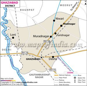
Ghaziabad (ग़ाज़ियाबाद) is an industrial city in the Indian state of Uttar Pradesh. It is located about 1.5 km east of the Hindon River at latitude 28° 40' north and longitude 77° 25' east. It is 19 km east of Delhi and 46 km southwest of Meerut. The city houses the headquarters of the Ghaziabad district. It was initially part of the Meerut district after independence, till the time when — due to some political intervention — Ghaziabad was separated and given a new district status. It is a large industrial city well-connected by roads and railways. It has industries that manufacture railway coaches, diesel engines, bicycles, tapestries, glassware, pottery, paint and varnish, heavy chains, etc.
Origin
The city gets its name from the founder Ghazi-ud-din, who called it Ghaziuddinnagar after himself. Later the name was shortened to Ghaziabad.
Tahsils in Ghaziabad district
Villages in Ghaziabad Tahsil
Afjalnagar Siti, Afzalpur, Agraula, Ahmad Nagar Nawada, Aliabad, Allipur, Arifpur, Asalatpur Farakh Nagar, Ataur, Aurangabad Ristal, Badarpur, Badshahpur Sirauli, Bahadurpur, Banthla, Behta Hajipur (CT), Bhanera Khurd, Bhawanipur, Bhikkanpur, Bhowapur, Chirauri, Dasna (NP), Dasna Dehat, Daultabad Motapur, Dharipur, Dharoti Khurd (CT), Didwari, Dinanathpur Puthi, Fatiyabad Nihaura, Ghaziabad (M Corp.). Haqiqatpur Urf Khudawas, Harampur, Ilaichipur, Inayatpur, Jafarabad Ganauli, Jalalabad Ghaziabad (जलालाबाद) (Nr. Muradnagar), Kanauja, Karim Nagar Katiyar Urf Akalpu, Khanpur Japti, Khora, Kotwalpur, Kushaliya, Lalpur, Loni (NP), Loni Dehat, Lutfulapur Navada, Madaul, Mahmoodpur, Mahmudabad, Makraida, Manota, Masauta, Masuri, Mathurapur, Matiala, Mewala Bhatti, Mirpur Hindu, Misbapur, Morti, Muhiddinpur Dabarsi, Murtazabad Bhoopkheri, Nagla Firoj Mohanpur, Nahal, Nanu, Narainpur Urf Rampur, Nasaratabad Kharkhari, Nauraspur, Nidori, Nig Rayati, Nistauli, Nurpur, Panchayara, Pavi Sadanapur, Raghunath Pur, Rasulpur Sikrod, Sadabad Durgavali, Sadarpur Ghaziabad, Sadat Nagar Ikla, Sadullabad, Samaypur, Shahpur Nij Morta, Shakar Pulla, Shamsher, Sharfuddinpur Javli, Sharifabad Rajapur, Sikhrani, Sirora Salempur, Tila Shahbazpur,
History
From the historical cultural, mythological and archaeological point of view Ghaziabad is a prosperous city. This has been proved from the research work and excavations done in the district. The excavation work carried out at the mound of Kaseri situated on the bank of river Hindon, 2 km north from Mohan Nagar shows that civilization was developed here in 2500 B.C.[1]
On the eastern border of the district is situated the village "KOT" which is associated with the famous emperor Samudra Gupta, who performed the Aswamedha yagya here after destroying the fort and "Kot Kuljam" (princes of the Kot dynasty).[1]
A fort standing in the city was attacked and sacked by Taimur in 1313.[2] Mughal King used to come here for hunting and pleasure trips. A Baage Ranap is a memorial of that period.
The modern city of Ghaziabad was founded in 1740 by the vizir Ghazi-un-ddin, the minister of Moghul Emperor Ahmadshah and Alamgir IInd. He named it after himself and called it Ghaziuddinnagar. He built a spacious sarai consisting of 120 rooms of masonry with pointed arches. As per records this city was constructed within the boundary of four giant doors and a huge inn (Sarai) of 120 rooms was built. These four doors were named Dasna Gate, Sihani Gate, Delhi Gate and Shahi Gate respectively. Only the gate, a few portions of the boundary wall and a massive pillar about fourteen feet in height remains now, the precincts now being inhabited. Later on Shahi gate was renamed as Bazar Gate and after independence it was renamed as Jawahar Gate. The other three gates carry the old name as it is. Before 1740 it was a some sort of picnic place of Mughal Emperors. There are small villages called Kaila, Bonjha, and Jatwara. His mausoleum still stands in the city but is in disrepair.
The Jat Raja, Maharaja Surajmal was killed near the city by the Rohillas in 1763.
The city was the scene of fighting during the Indian independence movement, 1857–58, revolt that began with Indian soldiers in the Bengal army of the British East India Company but developed into a widespread uprising against British rule in India. In an encounter between the freedom fighters and a small British force the former were defeated while trying to hold the Hindon. The first confrontation with British soldiers on the bank of Hindon River in 1857 while coming from Meerut. Graves of British Soldiers and Officers killed on 30th and 31st may, 1857 can be seen today at the Meerut Road Crossing near Hindon River.
Geography
Ghaziabad is situated about 2.5 km from the Hindon river. On the north it is bound by the district of Meerut, on the south by that of Bulandshahar and Gautambudh Nagar, on the south-west by Delhi and on the east by the district Jyotibaphule Nagar. As its boundary is adjacent to Delhi, it acts as the main entrance to Uttar Pradesh and hence is also called the Gateway of Uttar Pradesh.
Ganga, Yamuna and Hindon are the main rivers flowing through the district and they are filled with water throughout the year. Other than these there are some small rain-fed rivers, prominent among them is the Kali river. Apart from these rivers the Ganaga Canal flows through the district and irrigation work is carried out through different branches of the canal. The Ganga canal also caters to the drinking water needs of the people of Ghaziabad as well as Delhi.
Jat villages in Ghaziabad
Abupur (अबुपुर),
Jalalabad Ghaziabad (जलालाबाद) (Nr. Muradnagar),
Duhai (दुहाई),
Sadarpur (सदरपुर),
Penga (पेंगा),
Patla (पतला),
Begamabad (बेगमाबाद),
Budana (बुदाना),
Arthala (अर्थला),
Khurampur (खुरमपुर),
Manota (मनौटा),
Kadarabad (कादराबाद),
Sahibabad,(साहिब।ब।द),
Ataur (अटौर)
Razapur (रजापुर)
Mehrauli Ghaziabad (महरौली गाजियाबाद)
Raispur (रईसपुर)
External links
References
Back to Jat Villages
External links
- http://ghaziabad.nic.in Ghaziabad
