Madhopur Pathankot
- For similar villages see Madhopur
| Author: Laxman Burdak IFS (R) |
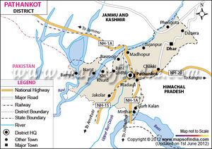
Madhopur (माधोपुर) is a village in district Pathankot in Punjab.
Location
Madhopur is a town located in Pathankot district Punjab, India, at its border with the Kathua district of Jammu and Kashmir. It is also the location of the Madhopur headworks on the Ravi River, which feeds the Upper Bari Doab Canal irrigating 335,000 hectares of land in Punjab. Madhopur has an average elevation of 332 metres (1,089 feet), and lies on the highway NH 44 (formerly NH-1A) linking Punjab and Jammu and Kashmir.
Origin
History
Madhopur was part of the Nurpur Princely state ruled by the Pathanias prior to 1849 A.D. Now it is known as the "Gateway of Punjab", a meeting point of the three northern states of Punjab, Himachal Pradesh and Jammu and Kashmir. Due to its location, Madhopur serves as a travel hub for those three, and is a hub for the Indian Army. Madhopur is a small Punjab town in terms of population. It is the last point in Punjab on the national highway that connects Jammu and Kashmir with the rest of India.
The Upper Bari Doab Canal starts from here, which is best known for its Hydraulic Research Station at the Upper Bari Doab Canal in Malikpur Sujanpur.
Madhopur is situated in the foothills of Kangra and Dalhousie, with the Ravi River flowing close by. The city is sometimes used as a rest-stop before heading into the mountains of Jammu and Kashmir, Dalhousie, Chamba, and Kangra, into the Himalayas.
Shahpur Kandi Fort
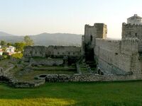
Named after Mughal emperor Shah Jahan, this fort is the major tourist attraction of Pathankot in Punjab. Nestled in the foothills of the majestic Himalayas, the fort gives an insight into Pathankot's rich tradition and history. What makes the fort worth visiting is its intricate carvings, magnificent construction and the fact that it offers great views of the picturesque Himalayan foothills and the Ravi river. The ruins around the fort that were destroyed during the British rule, are also worth visiting as they speak volumes about the glorious past of the Pathania dynasty.
The fort was built by Shah Jahan's chief, Jaspal Singh Pathania, in 1505, with an aim to protect regions of Nurpur and Kangra. The fort also served as the last refuge of Ram Singh Pathania in 1848 AD when he rebelled against the atrocities of British rule.[1]
Close to the India-Pakistan border on the Madhopur Road is a village called Shahpur. There on the left bank of River Ravi one can find a beautiful fort built by Pathania ruler Jaspal Singh in the early 16th century. Although the fort has now been transformed into a guest house it still possesses a charm of its own. Indeed, if your dream is to spend few days among the historical grandeur, Shahpur Kandi Fort is the ideal place. Since the fort is located at a distance of 17.5 Km from Pathankot, one can also go there for a day’s trip.
Historical Background of Shahpur Kandi Fort
For centuries Pathankot had been the seat of the Pathania Kings of Punjab. It is believed that a branch of Chandrabangshi Tomars led by Rana Jethpal came to this region from Delhi more than 1000 years ago to carve out a kingdom of their own. They first settled down in the Jalandhar Doab; later they conquered a fort called Bhet and finally came to Pathankot, then known as Paithan. We do not exactly know where they lived before they built the fort at Shahpur Kandi, but we do know that once they conquered Paithan they began to be known as Pathania kings.
Strategic Importance of Shahpur Kandi Fort
As we have already said, the Shahpur Kandi Fort was built by King Jaspal Singh Pathania in the year of 1505. Indeed, the site must have been chosen with care. Located at the foothills of Shiwalik Mountains on the left bank of River Ravi, this fort not only offered a safe haven for the kings, but also helped them to retain their control over their entire kingdom. At that time it not only comprised of the Pathankot region, but also Nurpur and Kangra. Although the capital was later shifted to Nurpur| (now in Himachal Pradesh), its importance was never diminished.
History of Shah Kandi Fort
Anybody who is interested in the history of this region must have heard of Ram Singh Pathania. It was from this fort that he fought most of his battles. In fact, Shahpur Kandi Fort was the last refuge of this brave prince.
By then, the capital had shifted to Nurpur. Since the true heir to the throne was a minor, Ram Singh carried on the kingly duties on his behalf. However, the British had other designs and wanted somebody else to sit on the throne. Ram Singh rebelled against the British when in 1848 AD the representative of the state was insulted by them. Several wars broke out between the two sides, but Ram Singh Pathania could not be subdued. He even recaptured the Shahpur Kandi Fort from the British and made sure that the British did not get any foothold here.
Unfortunately, a Brahmin told the British where and when the brave Ram Singh could be found unarmed and alone for petty gains. Finally Ram Singh was captured while offering prayers. He was tried and deported to Rangoon. He died there on 11th November, 1856. However, he is still remembered by the people here through different ballads and fairs.
Source - https://www.pathankotonline.in/city-guide/shahpur-kandi-fort-near-pathankot
Jat Gotras
माधोपुर
माधोपुर (Madhopur) भारत के पंजाब राज्य के पठानकोट ज़िले में स्थित एक गाँव है। यह जम्मू और कश्मीर की राज्य सीमा पर है और सीमा के पार कठुआ ज़िला है। गाँव से उत्तर में रावी नदी बहती है। माधोपुर पंजाब के अंतिम उत्तरी छोर पर स्थित है और यहाँ से रावी नदी को पार करके जम्मू एवं कश्मीर राज्य प्रारंभ हो जाता है। व्यापारिक, सामरिक और भौगोलिक रूप से इसका महत्व और भी ज्यादा हो जाता है, क्योंकि भारत को जम्मू और कश्मीर से जोड़ने वाला एकमात्र राष्ट्रीय राजमार्ग और भारतीय रेल यहीं से होकर गुज़रती है। इस कारण इसे पंजाब के प्रवेशद्वार के रूप से जाना जाता है। यह क्षेत्र पर्यटन की दृष्टि से एक अच्छा स्थान है। हिमालय की शिवालिक पहाड़ियों और रावी के किनारे किनारे बनी सड़क का नजारा अत्यंत ही मनमोहक है।
इतिहास: माधोपुर पहले पहाड़ी राज्यों के शासन के अधीन था। महाराजा रणजीत सिंह ने भी माधोपुर पर शासन किया है इसके प्रमाण महाराजा रणजीत सिंह के राज्यकाल का महल आज भी यहाँ से 5 किलोमीटर दूर शाहपुर कंडी में स्थित है। अंग्रेजों के काल के गिरिजाघर, परियों का बाग, लाल कोठी, ऊपरी बारी दोआब नहर, निचली बारी दोआब नहर और अन्य कई इमारतें आज भी यहाँ मौजूद है।
Population
At the time of Census-2011, the population of Madhopur village stood at 2265, with 398 households.
Notable Persons
External Links
References
Back to Jat Villages

