Lycia
| Author: Laxman Burdak, IFS (R). |

Lycia was a geopolitical region in Anatolia in what are now the provinces of Antalya and Muğla on the southern coast of Turkey, and Burdur Province inland.
Location
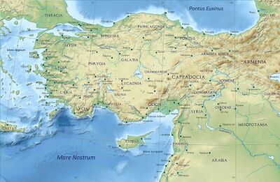
The borders of Lycia varied over time, but at its centre was the Teke peninsula of southwestern Turkey, which juts southward into the Mediterranean Sea, bounded on the west by the Gulf of Fethiye, and on the east by the Gulf of Antalya. Lycia comprised what is now the westernmost portion of Antalya Province, the easternmost portion of Muğla Province, and the southernmost portion of Burdur Province. In ancient times the surrounding districts were, from west to east, Caria, Pisidia, and Pamphylia, all equally as ancient, and each speaking its own Anatolian language.
The name of the Teke Peninsula comes from the former name of Antalya Province, which was Teke Province, named from the Turkish tribe that settled in the region.
Variants of name
- Lўcia and Lycians (Anabasis by Arrian, p. 67, 68, 80, 125, 151, 308.)
- Lycia (Pliny.vi.39)
- Antalya
- Lycian
- 𐊗𐊕𐊐𐊎𐊆𐊖 Trm̃mis (Lycian)
- Lykia/Lykía (Greek:Λυκία)
- Likya (Turkish)
- Lukka
Jat clans
- Luka - Jat clan Luka may derive from Lukka country in southwestern Anatolia, corresponding to later Lycia.
Jat Gtras Namesake
- Luka = Lukka = Lўcia and Lycians (Anabasis by Arrian, p. 67, 68, 80, 125, 151, 308.)
Jat Gtras Namesake
- Luka = Lukka = Lycia (Pliny.vi.39)
Physical geography
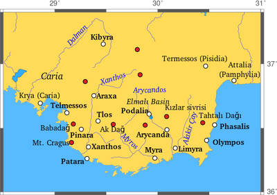
Four ridges extend from northeast to southwest, roughly, forming the western extremity of the Taurus Mountains. Furthest west of the four are Boncuk Dağlari, or "the Boncuk Mountains," extending from about Altinyayla, Burdur, southwest to about Oren north of Fethiye. This is a fairly low range peaking at about 2340 m. To the west of it the steep gorges of Dalaman Çayi ("the Dalaman River"), the ancient Indus, formed the traditional border between Caria and Lycia. The stream, 229 km long, enters the Mediterranean to the west of modern-day Dalaman. Upstream it is dammed in four places, after an origin in the vicinity of Sarikavak in Denizli Province.
The next ridge to the east is Akdağlari, "the White Mountains," with a high point at Uyluktepe, "Uyluk Peak. This massif may have been ancient Mount Cragus. Along its western side flows Eşen Çayi, "the Esen River," anciently the Xanthus, Lycian Arñna, originating in the Boncuk Mountains, flowing south, and transecting the several-mile-long beach at Patara. The Xanthus Valley was the country called Tŗmmis in dynastic Lycia, from which the people were the Termilae or Tremilae, or Kragos in the coin inscriptions of Greek Lycia: Kr or Ksan Kr. The name of western Lycia was given by Charles Fellows to it and points of Lycia west of it.
The next ridge to the east, Beydağlari, "the Bey Mountains," peaks at Kizlarsevrisi, the highest point of the Teke Peninsula. It is most likely the ancient Masicytus range. Between Beydağlari and Akdağlari is an upland plateau, Elmali, where ancient Milyas was located. The elevation of the town of Elmali, which means "Apple Town," from the density of fruit-bearing groves in the region, which is the highest part of the valley below it. Fellows considered the valley to be central Lycia.
The Akçay, or "White River," the ancient Aedesa, brought water from the slopes to the plain, where it pooled in two lakes below the town, Karagöl and Avlangöl. Currently the two lakes are dry, the waters being captured on an ongoing basis by irrigation systems for the trees. The Aedesa once drained the plain through a chasm to the east, but now flows entirely through pipelines covering the same route, but emptying into the water supplies of Arycanda and Arif. An effort has been made to restore some of the cedar forests cleared in antiquity.[1]
The easternmost ridge extends along the east coast of the Teke Peninsula, and is called, generally, Tahtali Dağlari, "The Tahtali Mountains." The high point within them is Tahtali Dağ, dubbed "Mount Olympus" in antiquity by the Greeks, remembering Mount Olympus in Greece.[2] These mountains create a rugged coastline called by Fellows eastern Lycia. Much of it has been reserved as Olimpos Beydağlari Parki. Within the park on the slopes of Mt. Olympus is a U-shaped outcrop, Yanartaş, above Cirali, from which methane gas, naturally perpetually escaping from below through the rocks, feeds eternal flames. This is the location of ancient Mount Chimaera.
Through the cul-de-sac between Baydağlari and Tahtalidağlari, the Alakir Çay ("Alakir River"), the ancient Limyra, flows to the south trickling from the broad valley under superhighway D400 near downtown Kumluca across a barrier beach into the Mediterranean. This configuration is entirely modern. Upstream the river is impounded behind Alakir Dam to form an urban-size reservoir. Below the reservoir a braided stream alternates with a single, small channel flowing through irrigated land. The wide bed gives an indication of the former size of the river. Upstream from the reservoir the stream lies in an unaltered gorge, flowing from the slopes of Baydağlari. The ancient route to Antalya goes up the valley and over the cul-de-sac, as the coast itself is impassible except by boat. The valley was the seat of ancient Solymus, home of the Solymi.
Demography
The ancient sources mention about 70 settlements of Lycia. These are situated either along the coastal strip in the protecting coves or on the slopes and hills of the mountain ranges. They are often difficult to access, which in ancient times was a defensive feature. The rugged coastline favored well-defended ports from which, in troubled times, Lycian pirate fleets sallied forth.
The principal cities of ancient Lycia were Xanthos, Patara, Myra, Pinara, Tlos and Olympos (each entitled to three votes in the Lycian League) and Phaselis. Cities such as Telmessos and Krya were sometimes listed by Classical authors as Carian and sometimes as Lycian. Further information: List of Lycian place names
History
Known to history since the records of ancient Egypt and the Hittite Empire in the Late Bronze Age, it was populated by speakers of the Luwian language group. Written records began to be inscribed in stone in the Lycian language (a later form of Luwian) after Lycia's involuntary incorporation into the Achaemenid Empire in the Iron Age. At that time (546 BC) the Luwian speakers were decimated, and Lycia received an influx of Persian speakers.
Lycia fought for the Persians in the Persian Wars, but on the defeat of the Achaemenid Empire by the Greeks, it became intermittently a free agent. After a brief membership in the Athenian Empire, it seceded and became independent (its treaty with Athens had omitted the usual non-secession clause), was under the Persians again, revolted again, was conquered by Mausolus of Caria, returned to the Persians, and finally fell under Macedonian hegemony upon the defeat of the Persians by Alexander the Great. Due to the influx of Greek speakers and the sparsity of the remaining Lycian speakers, Lycia was rapidly Hellenized under the Macedonians, and the Lycian language disappeared from inscriptions and coinage.
On defeating Antiochus III in 188 BC the Romans gave Lycia to Rhodes for 20 years, taking it back in 168 BC. In these latter stages of the Roman republic Lycia came to enjoy freedom as a Roman protectorate. The Romans validated home rule officially under the Lycian League in 168 BC. This native government was an early federation with republican principles; these later came to the attention of the framers of the United States Constitution, influencing their thoughts.[3]
Despite home rule, Lycia was not a sovereign state and had not been since its defeat by the Carians. In 43 AD the Roman emperor Claudius dissolved the league, and Lycia was incorporated into the Roman Empire with provincial status. It became an eparchy of the Eastern, or Byzantine Empire, continuing to speak Greek even after being joined by communities of Turkish language speakers in the early 2nd millennium. After the fall of the Byzantine Empire in the 15th century, Lycia was under the Ottoman Empire, and was inherited by the Turkish Republic on the fall of that empire. The Greek and Turkish population was exchanged when the border between Greece and Turkey was negotiated in 1923.
Alexander's invasion
Arrian[4] writes that ...Then he (Alexander) invaded Lycia and brought over the Telmissians by capitulation; and crossing the river Xanthus, the cities of Pinara, Xanthus, Patara, and about thirty other smaller towns were surrendered to him. ...The Marmarians alone defended their city with desperate valour. They finally set fire to it, and escaped through the Macedonian camp to the mountains. [5] As to Xanthus the river, see Homer [6]
Acquisition of Lycia by Cyrus the Great
Herodotus writes more credibly of contemporaneous events, especially where they concerned his native land. Asia Minor had been partly conquered by the Iranians, starting with the Scythians, then the Medes. The latter were defeated by the Persians, who incorporated them and their lands into the new Persian Empire. Cyrus the Great, founder of the Achaemenid dynasty, resolved to complete the conquest of Anatolia as a prelude to operations further west, to be carried out by his successors. He assigned the task to Harpagus, a Median general, who proceeded to subdue the various states of Anatolia, one by one, some by convincing them to submit, others through military action.
Arriving at the southern coast of Anatolia in 546 BC, the army of Harpagus encountered no problem with the Carians and their immediate Greek neighbors and alien populations, who submitted peacefully. In the Xanthus Valley an army of Xanthians sallied out to meet them, fighting determinedly, although vastly outnumbered. Driven into the citadel, they collected all their property, dependents and slaves into a central building, and burned them up. Then, after taking an oath not to surrender, they died to a man fighting the Persians, foreshadowing and perhaps setting an example for Spartan conduct at the Battle of Thermopylae a few generations later. Coincidentally archaeology has turned up a major fire on the acropolis of Xanthus in the mid-6th century BC, but as Antony Keen points out, there is no way to connect that fire with the event presented by Herodotus. It might have been another fire.[7] The Caunians, says Herodotus, followed a similar example immediately after.[8] If there was an attempt by any of the states of Lycia to join forces, as happened in Greece 50 years later, there is no record of it, suggesting that no central government existed. Each country awaited its own fate alone.
Herodotus also says or implies that 80 Xanthian families were away at the time, perhaps with the herd animals in alpine summer pastures , but helped repopulate the place. However, he reports, the Xanthians of his time were mainly descended from non-Xanthians. Looking for any nuance that might shed light on the re-population of Xanthus, Keen interprets Herodotus' "those Lycians who now say that they are Xanthians" to mean that Xanthus was repopulated by other [[Lycians (and not by Iranians or other foreigners).[9] Herodotus said nothing of the remainder of Lycia; presumably, that is true because they submitted without further incident. Lycia was well populated and flourished as a Persian satrapy; moreover, they spoke mainly Lycian.
Ch 1.24 Alexander in Lycia and Pamphylia
Arrian[10] writes....Some of the Macedonians who served in Alexander's army had married just before he undertook the expedition. He thought that he ought not to treat these men with neglect, and therefore sent them back from Caria to spend the winter in Macedonia with their wives. He placed them under the command of Ptolemy, son of Seleucus, one of the royal body-guards, and of the two generals Coenus, son of Polemocrates, and Meleager, son of Neoptolemus, because they were also newly married. He gave these officers instructions to levy as many horse and foot soldiers as they could from the country, when they returned to him and brought back the men who had been sent away with them. By this act more than by any other Alexander acquired popularity among the Macedonians. He also sent Cleander, son of Polemocrates, to levy soldiers in Peloponnesus,[1] and Parmenio to Sardis, giving him the command of a regiment of the Cavalry Companions, the Thessalian cavalry, and the rest of the Grecian allies. He ordered him to take the wagons to Sardis and to advance from that place into Phrygia.
He himself marched towards Lycia and Pamphylia, in order to gain command of the coast-land, and by that means render the enemy's fleet useless. The first place on his route was Hyparna, a strong position, having a garrison of Grecian mercenaries; but he took it at the first assault, and allowed the Greeks to depart from the citadel under a truce. Then he invaded Lycia and brought over the Telmissians by capitulation; and crossing the river Xanthus, the cities of Pinara, Xanthus, Patara, and about thirty other smaller towns were surrendered to him.[2] Having accomplished this, though it was now the very depth of winter, he invaded the land called Milyas,[3] which is a part of Great Phrygia, but at that time paid tribute to Lycia, according to an arrangement made by the Great King. Hither came envoys from the Phaselites,[4] to treat for his friendship, and to crown him with a golden crown; and the majority of the maritime Lycians also sent heralds to him as ambassadors to treat for the same object. He ordered the Phaselites and Lycians to surrender their cities to those who were despatched by him to receive them; and they were all surrendered. He soon afterwards arrived himself at Phaselis, and helped the men of that city to capture a strong fort which had been constructed by the Pisidians to overawe the country; and sallying forth from which those barbarians used to inflict much damage upon the Phaselites who tilled the land.[5]
1. See Arrian, ii. 20 infra.
2. The Marmarians alone defended their city with desperate valour. They finally set fire to it, and escaped through the Macedonian camp to the mountains. See Diodorus (xvii. 28). As to Xanthus the river, see Homer (Iliad, ii. 877; vi. 172); Horace (Carm., iv. 6, 26).
3. Lycia was originally called Milyas; but the name was afterwards applied to the high table in the north of Lycia, extending into Pisidia. See Herodotus, i. 173.
4. Phaselis was a seaport of Lycia on the Gulf of Pamphylia. It is now called Tekrova.
5. He also crowned with garlands the statue of Theodectes the rhetorician, which the people of Phaselis, his native city, had erected to his memory. This man was a friend and pupil of Aristotle, the tutor of Alexander. See Plutarch (Life of Alex., 17); Aristotle (Nicom. Ethics, vii. 7).
See also
References
- ↑ Mountain and plain: from the Lycian coast to the Phrygian plateau in the late Roman and early Byzantine period, | Martin Harrison, Wendy Young, Ann Arbor,publisher:The University of Michigan Press, year=2001, p.48–50
- ↑ Tahtali Dagi (2366 m.), Antalya Website, 1996–2011, publisher:antalyaonline.net
- ↑ Bernstein, Richard (September 19, 2005). "A Congress, Buried in Turkey's Sand". The New York Times.
- ↑ Arrian:The Anabasis of Alexander/1b, Ch.24
- ↑ See Diodorus (xvii. 28).
- ↑ (Iliad, ii. 877; vi. 172); Horace (Carm., iv. 6, 26).
- ↑ Keen & (1998), p. 73.
- ↑ Histories, Book I, Section 176.
- ↑ Keen & (1998), p. 76.
- ↑ Arrian:The Anabasis of Alexander/1b, Ch.24

