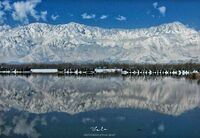
Zabarwan
| Author:Laxman Burdak, IFS (R) |

Zabarwan Range (ज़बरवन पर्वतमाला) is a short 32 km long sub-mountain range between Pir Panjal and Great Himalayan Range in the central part of the Kashmir Valley in the Union Territory of Jammu and Kashmir in India.[1]
Variants
Location
The Zabarwan Range borders the central part of the Kashmir Valley in the east. Literally it is the mountain range between Sind Valley and Lidder Valley on the north and south, and between the Zanskar Range and Jehlum Valley on the east and west, respectively.[2] Specifically the range is known to be what overlooks the Dal Lake and holds the Mughal gardens of Srinagar. The north end of the range lies in Ganderbal, while the south end lies in Pampore. The Shankaracharya Temple is built on the edge of the central part of the Zabarwan Range. The highest peak of this range is Mahadev Peak at 13,013 feet (3,966 m), which forms the distant background of the eastern mountain wall.[3]
On the northern slopes of the central part of the range there are three Mughal gardens built by Emperor Shah Jahan. These include Chashma Shahi, Nishat Bagh and Shalimar Garden alongside the Pari Mahal (the fairy palace). The recently built Indira Gandhi Memorial Tulip Garden in the lap of the Zabarwans is considered the largest tulip garden of Asia spread over 12 hectares of land.
Origin
Gabar of Zabar in Persian means high or superior.[4]
Jat clans
History
B S Dahiya[5] writes: The Gawars are mentioned in the Markandeya Purana as Gabalah. [6] Gabar of Zabar in Persian means high or superior.
ज़बरवन पर्वतमाला
ज़बरवन पर्वतमाला (Zabarwan Range) भारत के जम्मू और कश्मीर प्रदेश की कश्मीर घाटी के मध्य भाग में पीर पंजाल और महान हिमालय के बीच स्थित 32 किमी तक चलने वाली एक पर्वतमाला है। श्रीनगर की प्रसिद्ध डल झील के पीछे इसी शृंखला की पहाड़ियाँ दिखती हैं। 3,966 मीटर (13,012 फीट) ऊँचा महादेव पर्वत ज़बरवन पर्वतमाला का सबसे ऊँचा शिखर है। 141 वर्ग किमी क्षेत्रफल वाला दाचीगाम राष्ट्रीय उद्यान इसी पर्वतमाला के क्षेत्र में स्थित है।
External links
References
- ↑ "Srinagar City History". smcsite.org.
- ↑ "MANAGEMENT PLAN (2011-2016) DACHIGAM NATIONAL PARK" (PDF). jkwildlife.com.
- ↑ Mitra (2013). Jammu & Kashmir: Travel Guide. India. Ministry of Tourism. ISBN 9789380262451.
- ↑ B S Dahiya: Jats the Ancient Rulers (A clan study)/Jat Clan in India,p. 282
- ↑ B S Dahiya: Jats the Ancient Rulers (A clan study)/Jat Clan in India,p. 282
- ↑ op, cit, LVII, 36